

When modeling ignores observations: The Jiloca graben (NE Spain) and the Rubielos de la Cérida impact basin
by Kord Ernstson1 and Ferran Claudin2
June 2020
______________________________________________________________
Abstract. – The Iberian System in NE Spain is characterized by a distinctive graben/basin system (Calatayud, Jiloca, Alfambra/Teruel), among others, which has received much attention and discussion in earlier and very recent geological literature. A completely different approach to the formation of this graben/basin system is provided by the impact crater chain of the Rubielos de la Cérida impact basin as part of the important Middle Tertiary Azuara impact event, which has been published for about 20 years. Although the Rubielos de la Cérida impact basin is characterized by all the geological, mineralogical and petrographical impact findings recognized in international impact research, it has completely been hushed up in the Spanish geological literature to this day. The article presented here uses the example of the Jiloca graben to show the absolute incompatibility of the previous geological concepts with the impact structures that can be observed in the Jiloca graben without much effort. Digital terrain modeling and aerial photography together with structural and stratigraphic alien geology define a new lateral Singra-Jiloca complex impact structure with central uplift and an inner ring, which is positioned exactly in the middle of the Jiloca graben. Unusual topographic structures at the rim and in the area of the inner ring are interpreted as strike-slip transpression and transtension. Geological literature that still sticks to the old ideas and develops new models and concepts for the graben/basin structures, but ignores the huge meteorite impact and does not even enter into a discussion, must at best cause incomprehension.
Key words: Meteorite impact, Azuara impact event, Alfambra-Teruel graben, Calatayud basin, strike-slip transgression, transtension, Singra-Jiloca impact
______________________________________________________________
1 University of Würzburg, 97074 Würzburg (Germany), kernstson@ernstson.de 2 Associate Geological Museum Barcelona (Spain); fclaudin@xtec.cat
1 Introduction
According to current geological characterization, the Jiloca Graben in northeastern Spain is part of an important intramontane graben-basin system together with the Calatayud Basin/Graben and the Alfambra-Teruel Basin/Graben (Fig. 1), both terms being used synonymously in the literature. The origin of the remarkable topographic depression is controversial, and tectonic subsidence (Rubio and Simón 2007) and erosive deepening are mainly attributed to either Tertiary erosion pediplains or karst subrosion, whereby combined formation processes are also discussed (Casas-Sainz and Cortés-Gracia 2002) Gracia et al. 2003).
In the literature (e.g., Sanz de Galdeano et al. 2019, Gutiérrez et al. 2012) , the Jiloca graben is described as having originated in the Neogene and Quaternary, being limited by normal faults (the Menera and Palomera faults) with measurable several hundred meters throws, cutting pre-existent NW-SE striking folds. The sedimentary fill consists of at least 80 m thick Neogene and Quaternary.
The contradictory interpretations of the genesis of the Jiloca graben also find expression in the fact that the structure is called both a graben and sometimes a half-graben (Fig. 5.9. in [Sanz de Galdeano et al. 2019]).
In the aforementioned articles and even in the most recent literature, there is no mention of an approximately 20-year-old alternative hypothesis on the formation of the Jiloca graben in the context of discussions and publications on the large multiple Azuara impact with the formation of the Azuara impact structure and an associated Rubielos de la Cérida impact basin (Ernstson et al. 2001, 2002, 2003, Claudin et al. 2001, 2003, Schüssler et al. 2002, Hradil et al. 2001, Ernstson and Claudin, https://www.impact-structures.com/impact-spain/the-rubielos-de-la-cerida-impact-basin, no year). This is accompanied by the observation that the Azuara impact structure published since 1985 (Ernstson et al. 1985, 1987, 2002, Müller and Ernstson 1990, Ernstson and Claudin 1990, Ernstson 1994, Ernstson and Fiebag 1992 , Claudin and Ernstson (2012), Ernstson and Claudin https://www.impact-structures.com/impact-spain/the-azuara-impact-structure, no year) is not mentioned at all in the discussion of the other basin structures mentioned (Calatayud and Alfambra-Teruel), even in the latest geological literature (e.g. Sanchez et al. 2017, Casas-Sainz et al 2018, Gutiérrez et al. 2012, 2020, Simón et al. 2019, Sanz de Galdeano et al. 2019 ).
In view of this fact in the newer and most recent Spanish geological literature, we feel compelled to contrast the conventional ideas about the intramontane basins mentioned at the beginning with the extensive geological, mineralogical and petrographical findings from the Rubielos de la Cérida impact basin with the result that the formation hypotheses discussed so far can be geologically coherently replaced by the formation of the region in a massive impact event. We start here with a first article focusing on the Jiloca graben, which will be followed by further articles on the geological structure and the extensive impact finds and features of the entire Rubielos de la Cérida impact basin, which is not known on earth as its equal.
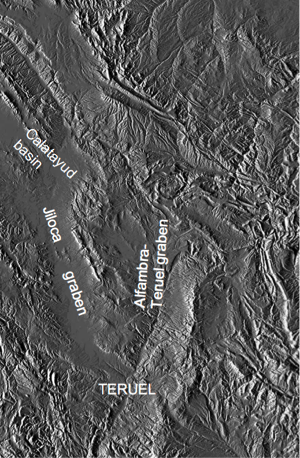
Fig.1. Standard graben/basin configuration on the Digital Terrain Modell (DTM source M. Cabedo).
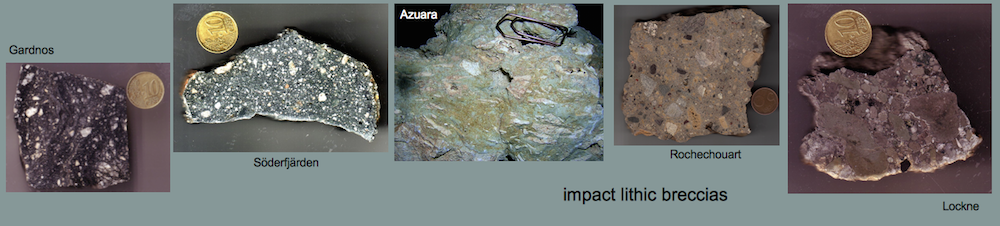
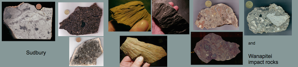
2 The Rubielos de la Cérida impact basin
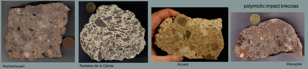
Originally, the Rubielos de la Cérida basin was defined by an approximately circular uplift of Mesozoic rocks (Fig. 2, 3), surrounded by a semi-circular to elliptical depression of Quaternary and post-impact Neogene deposits (Fig. 4; simplified and modified from the geological maps 1: 200.000; ITGE, 1991; IGME, 1986).
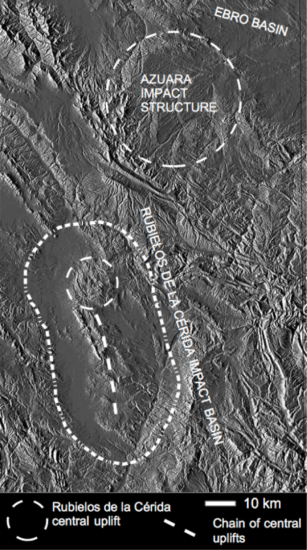
Fig. 2. The Azuara multiple impact event produced the more circular Azuara impact structure together with the elongated Rubielos de la Cérida impact basin.
This circular uplift with rocks of the Muschelkalk Fm. in the very center at the village of Rubielos de la Cérida and tectonically very surprising in the region, was, after abundant impact findings with clear shock metamorphism and structural abnormalities (Fig. 4), quickly recognized as a companion to the then already established Azuara impact structure (Ernstson et al (2002). Continuing geological investigations soon showed that from the central uplift there was an unmistakable extension of the structure towards Teruel, which continued to provide ample impact findings (Abb. 4) and led to the definition of a Rubielos de la Cérida impact basin (Ernstson et al. 2003).
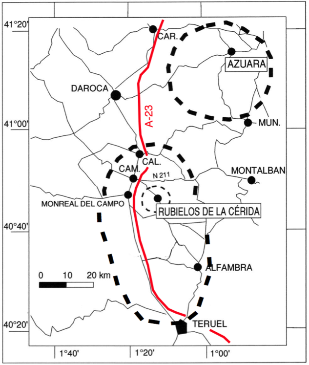
Fig. 3. Map for general orientation in the multiple impact field of the Azuara impact structure and the Rubielos de la Cérida impact basin. CAL. = Calamocha, CAM = Caminreal, CAR = Cariñna, MUN = Muniesa; A-23 = Autovía Mudéjar.
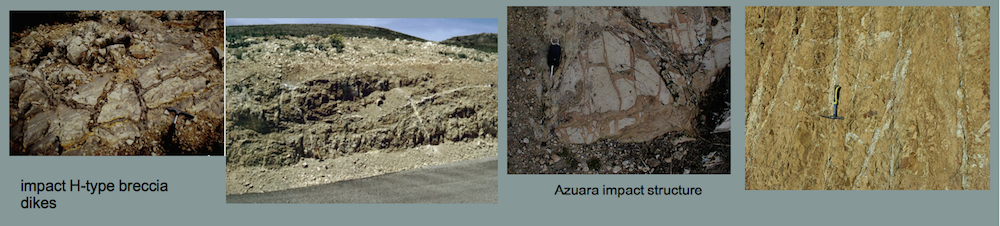
It soon became clear during the mapping of the geology in the basin that, apart from the Palomera steeply raised block (Figs. 5, 6), we were dealing with extreme structural compression along and within the Central uplift chain (Figs. 7-9), which goes against all assumptions of direct contact graben structures postulated west (Jiloca) and east (Alfambra/Teruel), but would provide a very strong argument for impact cratering processing (Fig. 10).
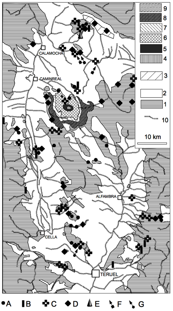
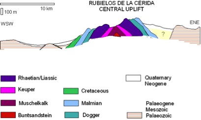
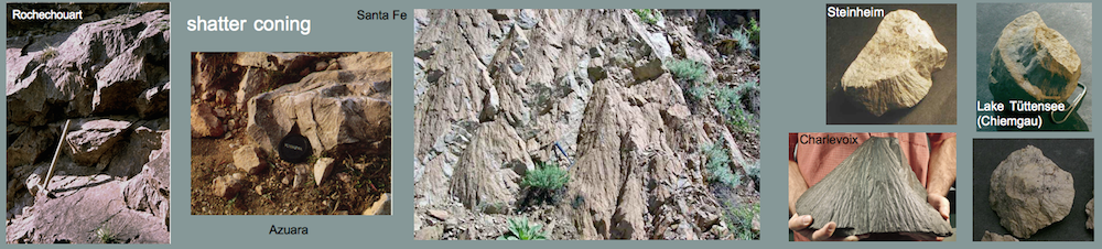
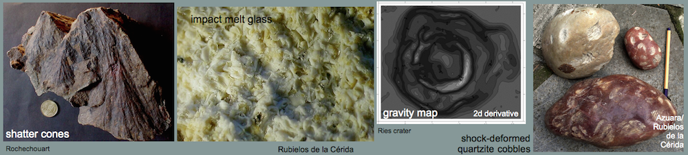
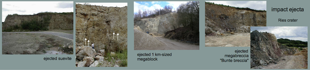
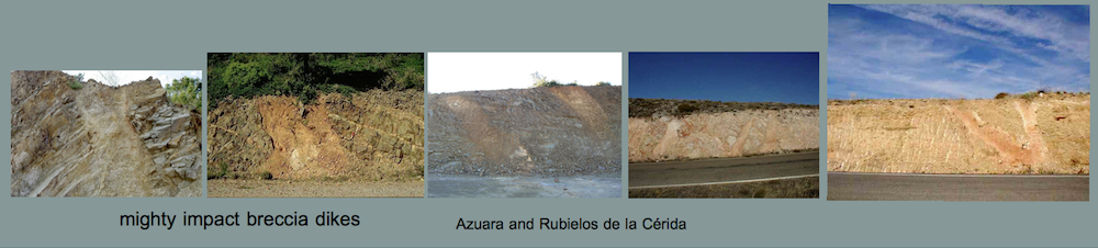
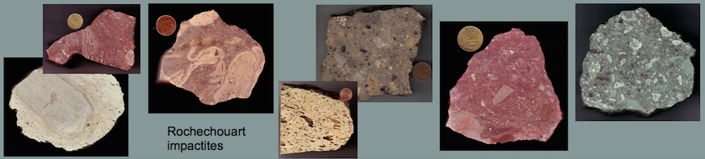
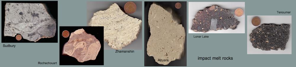
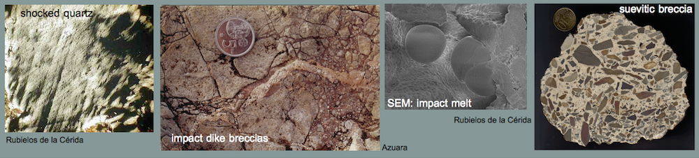
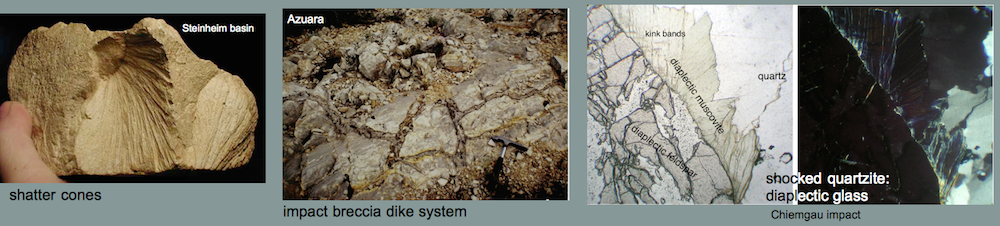
Fig. 4. Simplified geologic map of the Rubielos de la Cérida impact basin and major occurrences of impact features. 1 = Paleozoic, Mesozoic and Lower Tertiary, 2 = Upper Tertiary and Quaternary, 3 = Pelarda Formation ejecta, 4 = Muschelkalk, 5 = Keuper, 6 = Rhaethian and Liassic, 7 = Dogger, 8 = Malmian, 9 = Cretaceous, 10 = drainage pattern. A = basal suevite breccia, B = breccia dikes, C = megabreccias and monomictic movement breccias, D = shock metamorphism, E = shatter cones, F = impact melt rocks, suevites (Barrachina type) and suevite-like breccias, G = impact glass (pseudotachylite?). Also shown a WSW-ENE section of the central uplift.
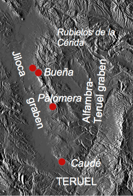
Fig. 5. Location of the exposures in Figs. 6-8.
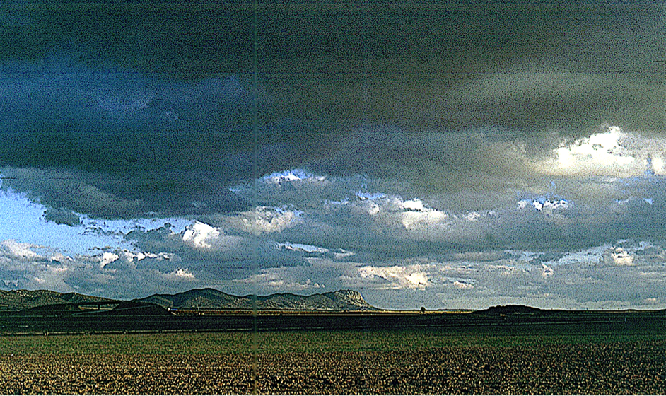
Fig. 6. Part of the central uplift chain (Sierra Palomera) emerging from the Quaternary of the impact basin (continuation of the Rubielos de la Cérida central uplift to the south; see Fig. 2).
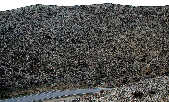
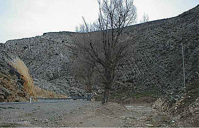
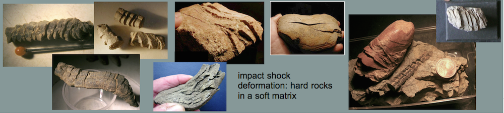
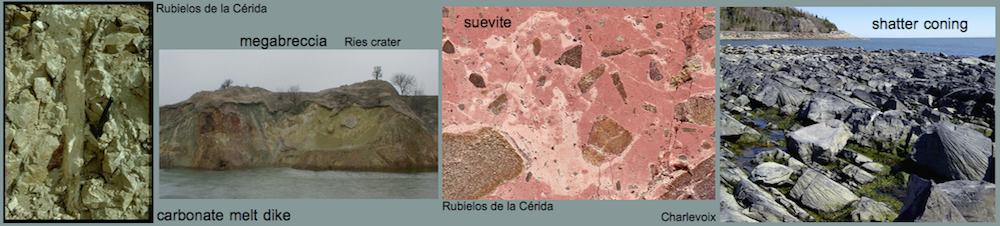
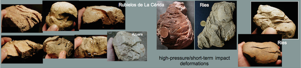
Fig. 7. Megabreccia near Bueña. Intense criss-cross layering of Jurassic limestones in the central uplift chain indicates extreme compression.
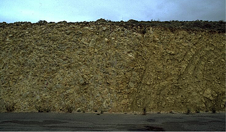
Fig. 8. Folding and megabrecciation of Jurassic limestones in the central-uplift chain (between Bueña and Caminreal). Note that only some “ghost” layering has survived the intense brecciation. As in Fig. 7 an extreme compression is indicated.
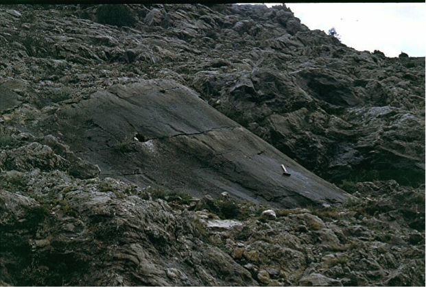
Fig. 9. The image shows part of an extended megabreccia deposit in the southern central uplift near Caudé. Within a chaotic accumulation of limestone blocks and fragments, a large surface displaying prominent striae and polish occurs (hammer length 40 cm). Any relation to tectonic structures is clearly missing. It is assumed that the peculiar deformations formed in the highly compressive process of the central uplift development (modification stage of impact cratering).
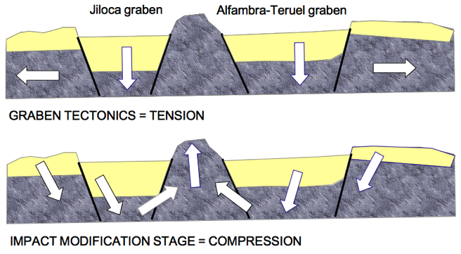
Fig. 10. Simple models of graben tectonics and impact cratering.
3 The Mesozoic uplift in the middle of the Jiloca graben
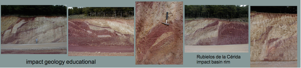
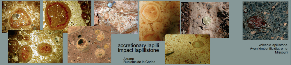
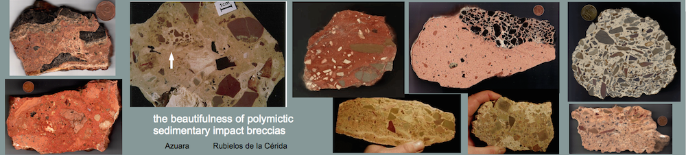
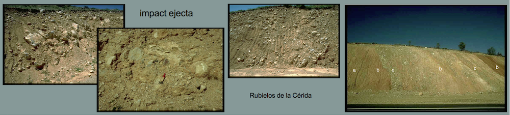
In the course of the field work in the Rubielos de la Cérida impact basin, the special stratigraphic constellation with the Buntsandstein hill northeast of Singra in the middle of the plain of the Neogene-Tertiary Jiloca Graben (Fig. 11) understandably attracted attention. As a silicate lithostratigraphic unit, it was an invitation to look for shock-metamorphic rocks, which led quite quickly to success (Fig. 4). The accompanying investigations on the stratigraphic outcrop of the Singra hill provided extensive further impact-specific evidence in the form of the suevite basal breccia, dike breccias and monomictic movement breccias, so that the whole complex together with the adjacent rising arch of Rhaetian and Liassic rocks were classified as impact-related.
Since this situation does not even exist in the latest geological literature, the basic discrepancy between conventional and impact-related interpretation is shown below, followed by a structural model, which also includes the morphological situation with the Digital Terrain Model (DTM).
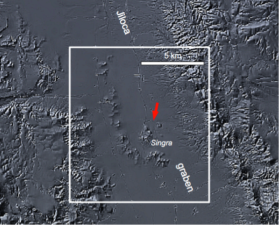
Fig. 11. Map section of the Jiloca graben in the Digital Terrain Model. The rectangle spans the generalized geologic map of the Mesozoic structure (arrow) in the middle of the Jiloca graben (Fig. 11).

Fig. 12. Geological sketch of the Mesozoic uplift in the middle of the graben. Legend of the stratigraphic units in Fig. 12. Copied from the maps 1 : 200 000, sheets Daroca and Teruel, and the maps 1 : 50 000, sheets Monreal del Campo (IGME 1983) and Santa Eulalia (IGME 1959). Because of its exotic stratigraphic position, the Upper Malmian (Kimmeridgian) block (C) must be considered as a dislocated megablock or assigned to downward “elevator” tectonics over enormous drop. The layer dip has been copied from the 1 : 50 000 maps.
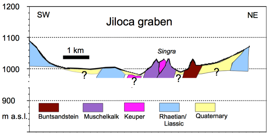
Fig. 13. Geological profile (see Fig. 12) of the uplift. The sketched dip of the units refers to Fig. 12.
As can be seen in Fig. 11, the unusual topographical situation of the structure can already be seen in the DTM, which will also be discussed later. Fig. 12 shows a highly simplified geological map for the rectangle with a restriction to an indexing of the Mesozoic units. For the white profile line Fig. 13 shows a corresponding section with the corresponding legend. In principle the structural situation is roughly half of the circular central uplift of Rubielos de la Cérida (Fig. 4). The impossibility of a Jiloca graben in its previous interpretation in this area cannot be better characterized than by this stratigraphically and structurally completely alien situation.
The position of this structure within the formation of the entire impact basin can only be conjectured. The most plausible explanation is the formation of a smaller side crater in the chain of adjacent central craters, with an inner ring and its own central uplift. The diameter may be estimated to roughly 10 km (see 5).
4 Transpression and transtension in complex impact structures
Transpression and transtension are strike-slip deformations that deviate from simple shear, when a component of shortening or extension orthogonal to the deformation zone occurs. These three-dimensional non-coaxial strains develop principally in response to obliquely convergent or divergent relative motions. For complex impact structures, Kenkmann and Dalwigk (2000) have shown that such deformations can be a new and noteworthy feature that arises in the modification phase of impact cratering during converging and diverging gravitational collapse movements.
Very simple models of these strike-slip deformations have been sketched in Fig. 14, which should serve to classify the very unusual morphological conditions in the Singra area (Fig. 15).
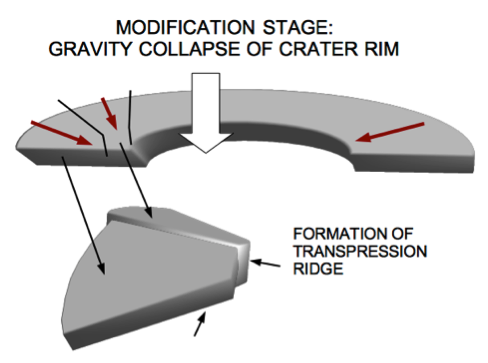
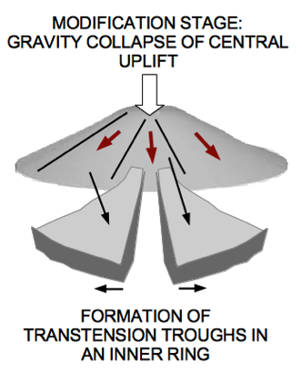
Fig. 14. Simple models of strike-slip transpression and transtension structures in complex impact craters.
A look at the DTM in Fig. 15 suggests that the postulated side crater with the uplift and a partially formed inner ring could be the result of exactly this strike-slip deformation. It is important to understand that these structures have not been noticed in previous mapping, where only a more or less elongated Rhaetian-Liassic stripe with partial anticlinal character was registered. Only with the DGM this quite unusual pattern of almost equally spaced narrow morphological bars is recognized, where the individual bars also show a certain elongation orthogonal to the postulated inner ring.
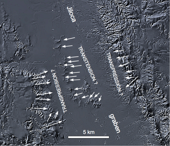
Fig. 15. Interpretation of unusual topographic features in the middle of the Jiloca graben as impact-related transpression and transtension structures.
5 The Singra-Jiloca crater
With the topographical and geological features discussed above and in view of the impact-related observations in the Singra uplift and on the neighboring Buntsandstein hill (Fig. 4), a remarkable lateral extension of the central uplift chain right through the middle of the Jiloca graben, as it has always been interpreted so far, becomes evident. Apart from the geologically fundamentally alien stratigraphic elevations in the middle of the graben, this insight is made possible above all by the high-resolution DTM (Fig. 15) and aerial imagery (Google Earth, Fig. 16) , which clearly show impact-related features.
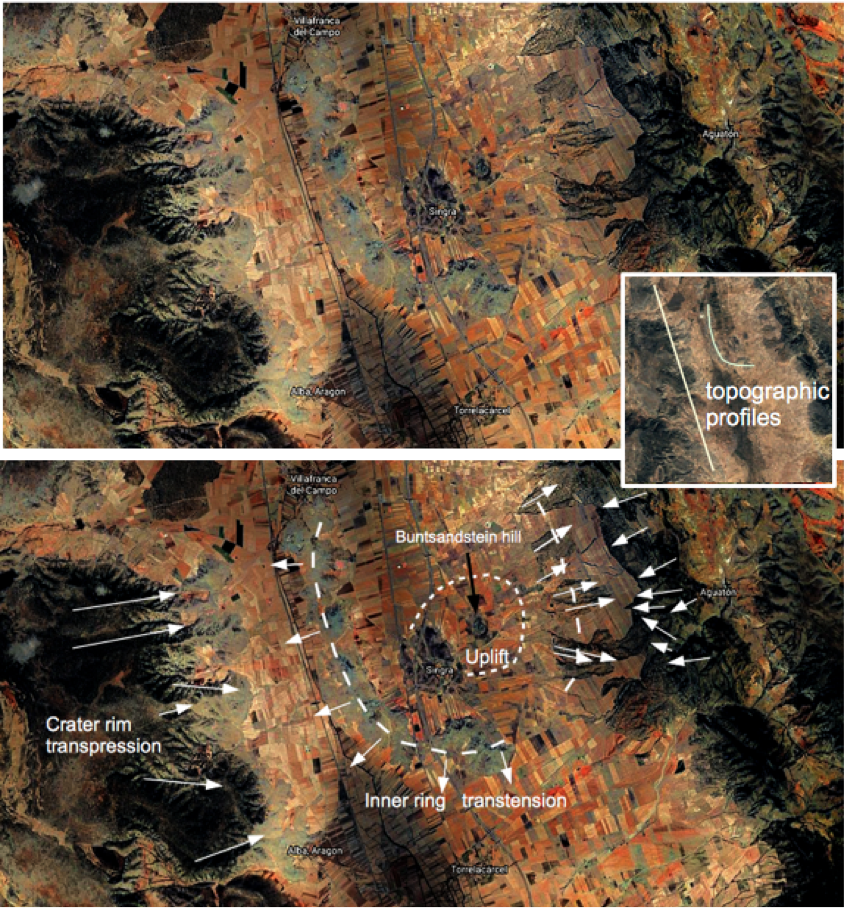
Fig. 16. Aerial photograph (Google Earth) in which the special topographic position of the Singra-Jiloca structure with postulated transpression and transtension is also clearly visible. For the white lines marked in the small image inset, Fig. 17 shows the profiles of the terrain elevations taken from the Google map.
The topographical peculiarities should not be overstressed here, especially since the geological maps give practically no better stratigraphic itemization of a transpression at the crater rim, but the conspicuous correspondence of the peculiar structures exactly in this area (Figs. 16, 17) strongly supports the reality of this Singra-Jiloca complex impact structure as a lateral companion to the main impact chain extending between the Rubielos de la Cérida uplift and Teruel.
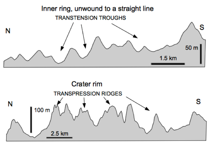
Fig. 17. The terrain forms along the profiles in Fig. 16 interpreted as transpression and transtension support this point of view, whereby almost periodically occurring ridges of a transpression and troughs of a transtension appear to be formed. Source Google Earth.
For the time being, questions remain unanswered regarding the extension of the Singra-Jiloca structure in the form of the inner ring to the north (Figs. 15, 16) and a certain topographic west-east asymmetry at the edge of the Sierra Palomera (Figs. 16). From the point of view of a complex impact cratering, the formation of the central mountain chain with primary compression and subsequent partial collapse and laterally strong pressure to the outside – here especially in the area of the Palomera uplift – cannot have remained without influence on the more or less simultaneous formation of the Singra-Jiloca structure, and a consequently formed asymmetry is not necessarily surprising.
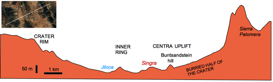
Fig. 18. A diametrical elevation profile through the structure across the Jiloca graben provides an appropriate interpretation and at the same time once again highlights the contrast between the traditional geological approach on the one hand and the coherent results of impact research on the other.
6 Discussion and conclusions
The starting point for this article was described at the beginning and refers to the fact that the great multiple impact event that formed the Azuara impact structure and the associated Rubielos de la Cérida impact basin does not occur in the newer and most recent Spanish geological literature, and even these terms do not appear in the indexes of textbooks on Spanish geology. We have taken this as an opportunity to show by means of an example how ignoring the extensively published impact material on the impacts means that old and long outdated views on the Tertiary geology of the Iberian system are being perpetuated, and also very special aspects of tectonics and geophysical, e.g. seismological, conditions are necessarily misleading.
The structure of the Jiloca Graben taken here as an example is symptomatic for this conflict, which in the conventional view works with model conceptions (here: tectonic graben lowering or erosion with subrosion and karst) of a whole graben/basin system, but ignores simple geological observations. We have already made similar experience in connection with the ejecta of the Azuara impact structure (Pelarda Formation) and the remarkable impact thrust of Daroca (Claudin and Ernstson 2019, 2020, and references therein).
With regard to the Jiloca graben, we would like to concede that this striking depression, in a relatively cursory view and discussion, has certainly offered itself as a graben formation, and even with regard to the impact, the Jiloca graben and the Alfambra/Teruel graben belong to graben-like depressions between Rubielos de la Cérida’s central uplift and the basin rim. That the discrepancy between tectonic graben subsidence and impact interpretation due to the enormous stratigraphic uplift at Singra and the enormous subsidence of the Kimmeridgian block directly next to it, and all that in the middle of the Jiloca graben, should have given food for thought. This should be put aside here, as should the published impact shock-metamorphic effects throughout the entire impact basin.
The new view of an independent lateral crater with a central uplift and inner ring with a diameter of perhaps 10 km, which is now located exactly in the middle of the formerly interpreted Jiloca graben, results mainly from the use of the DTM digital terrain model and the so very informative historical aerial photographs of Google Earth, which have been changing over 30 years. Both strongly reinforce the interpretation as a new impact structure belonging to the multiple Azuara impact event and should not allow the tectonic or subrosion-affected Jiloca graben to continue to exist geologically. This should also apply without restriction to the Alfambra/Teruel graben as part of the Rubielos de la Cérida impact basin and all related geotectonic work and processing in the region (e.g., Anchuela et al. 2016, Arlegui 2006, Casas-Sainz & Cortés-Gracia 2002, Casas-Sainz et al. 2018, Casas et al. 2000, Ezquerro et al. 2019, 2020, Gutiérrez et al 2012, 2020, Sanz de Galdeano et al 2019, Simón et al 2005, 2012, 2017).
References
Anchuela, O.P., Lafuente, P., Arlegui, L.E., Liesa, C.L., Simón, J.L. (2016): Geophysical characterization of buried active faults: the Concud Fault (Iberian Chain, NE Spain). – J. Earth Sci., 105, 2221-2239.
Arlegui L.E., Simón, J.L., Lisle, R.J., Orife, T. (2006) Analysis of non-striated faults in a recent extensional setting: the Plio-Pleistocene Concud fault (Jiloca graben, eastern Spain). J. Struct. Geol., 28, 1019–1027.
Casas-Sainz, A. M. & Cortés-Gracia, A. L. (2002): Cenozoic landscape development within the central Iberian Chain, Spain. – Geomorphology, 44(1), 19-46.
Casas-Sainz, A.M., Gil-Imaz, A., Simón, J.L., Izquierdo Llavall, Aldega, E.L., Román-Berdiel, T., Osácar, M.C., Pueyo-Anchuela, O., Ansón, M., García-Lasanta, C., Corrado, S., Invernizzi, C., Caricchi, C. (2018): Strain indicators and magnetic fabric in intraplate fault zones: Case study of Daroca thrust, Iberian Chain, Spain. – Tectonophysics, 730, 29-47.
Casas, A.M., Casas, A., Perez, A., Tena, S., Barrier, L., Gapais, D. and Nalpas, T. (2000): Syn-tectonic sedimentation and thrust-and-fold kinematics at the intra- mountain Montalbán Basin (northern Iberian Chain, Spain). Geodinamica Acta, 1: 1-17.
Claudin, F. and Ernstson, K. (2003): Geologia planetaria y Geologia regional: el debate sobre un impacto múltiple en aragón. Enseñanza de las ciencias de la Tierra, vol 11, nº 3, pp 202-212.
Claudin, K., Ernstson, K., Rampino, M.R., and Anguita, F.(2001): Striae, polish, imprints, rotated fractures, and related features in the Puerto Mínguez impact ejecta (NE Spain). Abstracts, 6th ESF IMPACT workshop, Impact Markers in the Stratigraphic record, pp. 15-16.
Claudin, F. and Ernstson, K. (2012): Azuara impact structure: The Daroca thrust geologic enigma – solved? A Ries impact structure analog. – https://www.impact-structures.com/2012/09/azuara-impact-structure-the-daroca-thrust-geologic-enigma-solved/
Claudin, F. and Ernstson, K. (2020): Daroca thrust (Iberian Chain, Spain) and the Azuara impact structure – the controversy continues. – https://www.impact-structures.com/2020/03/daroca-thrust-iberian-chain-spain-and-the-azuara-impact-structure-the-controversy-continues.
Claudin, F. and Ernstson, K. (2019): La formación Pelarda: eyecta de la estructura de impacto de Azuara (España): características deposicionales, edad y génesis. – http://estructuras-de-impacto.impact-structures.com/wp-content/uploads/2018/09/Pelarda-final-rudita-corrected-Komprimiert.pdf.
Claudin, F., Ernstson, K., and Monninger, W. (2019): New approach to an old debate: The Pelarda Formation meteorite impact ejecta (Azuara structure, Iberian Chain, NE Spain) . – https://www.impact-structures.com/wp-content/uploads/2019/08/Artikel-Pelarda-31.8.2019.-Komprimiert.pdf.
Ernstson, K., Hamman, W., Fiebag, J. & Graup, G. (1985): Evidence of an impact origin for the Azuara structure (Spain). – Earth Planet. Sci. Let., 74, 361-370.
Ernstson, K., Feld, H. & Fiebag, J. (1987): Impact hypothesis for the Azuara structure (Spain) strengthened. – Meteoritical Society Meeting, Newcastle upon Tyne, 1987. – Meteoritics, 22, 373.
Ernstson, K., Claudin, F., Schüssler, U., Hradil, K. (2002): The mid-Tertiary Azuara and Rubielos de la Cérida paired imapct structures (Spain). Treb. Mus. Geol. Barcelona, 11, 5-65.
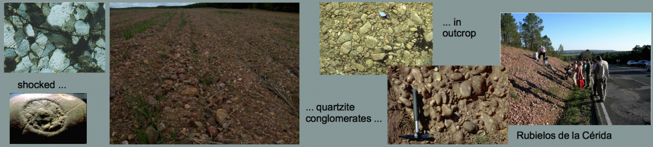
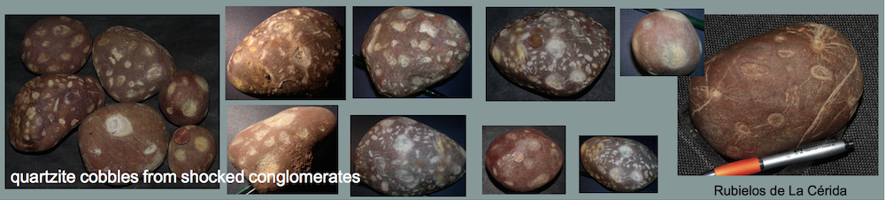
Ernstson, K., Rampino, M.R. & Hiltl, M. (2001): Cratered of cobbles in Triassic Buntsandstein conglomerates in NE Spain: Shock deformation of in-situ deposits in the vicinity of large impacts. Geology, v. 29, no.1, 11-14.
Ernstson, K., Claudin, F., Schüssler, U., Anguita, F, and Ernstson, T. (2001): Impact melt rocks, shock metamorphism, and structural features in the Rubielos de la Cérida structure, Spain: evidence of a companion to the Azuara impact structure. Abstracts, 6th ESF IMPACT workshop, Impact Markers in the Stratigraphic record, pp. 23-24.
Ernstson, K., Rampino, M.R., and Hiltl, M. (2001): Shock-induced spallation in Triassic Buntsandstein conglomerates (Spain): an impact marker in the vicinity of large impacts. Abstracts, 6th ESF IMPACT workshop, Impact Markers in the Stratigraphic record, pp. 25-26.
Ernstson, K., Schüssler, U., Claudin, F., Ernstson, T. (2003): An Impact Crater Chain in Northern Spain. –Meteorite, 9, 35-39.
Ernstson, K. & Claudin, F.: Pelarda Formation (Eastern Iberian Cains, NE Spain) (1990): Ejecta of the Azuara impact structure. – N.Jb.Geol.Paläont.Mh., 1990, 581-599, 1990.
Ernstson, K. (1994): Looking for Geological Catastrophes: The Azuara Impact Case. – In: Extinción y registro fósil (Extinction and the fossil record, E. Molina, ed.), Cuadernos Interdisciplinares No. 5, 31-57, SIUZ.
Ernstson, K. & Fiebag, J. (1992): The Azuara impact structure (Spain): new insights from geophysical and geological investigations. – Int. J. Earth Sci., 81/2, 403-427.
Ernstson, K., Rampino, M.R., Anguita, F., Hiltl, M., and Siegert, I. (1999): Shock deformation of autochthonous conglomerates near the Azuara impact structure, Spain: Geological Society of America Abstracts with Program, v. 31, p. A-122.
Ernstson, K. and Claudin, F. (2016): Impact educational: The suevite layer outcrop near Fuentes Calientes, Rubielos de la Cérida impact basin (Spain). – https://www.impact-structures.com/impact-educational/the-suevite-layer-outcrop-near-fuentes-calientes-rubielos-de-la-cerida-impact-basin-spain/
Ezquerro, L.,. Simón, J.J., Luzón, A., Liesa, C.L. (2019): Alluvial sedimentation and tectono-stratigraphic evolution in a narrowextensional zigzag basin margin(northern Teruel Basin, Spain). – J. Palaeogeography, DOI: 10.1186/s42501-019-0044-4, 25 p.
Ezquerro, L., Luzón, A., Simón, J.J., Liesa, C.L. (2020): Segmentation and increasing activity in the Neogene-Quaternary Teruel Basin rift (Spain) revealed by morphotectonic approach. – J. Struct. Geol., 135, https://doi.org/10.1016/j.jsg.2020.104043.
Gracia, F.J., Gutiérrez, F., Gutiérrez, M. (2003): The Jiloca karst polje-tectonic graben (Iberian Range, NE Spain). Geomorphology 52, 215–231.
Gutiérrez, F., Gracia, F.J., Gutiérrez, M., Lucha, P., Guerrero, J., Carbonel, D., Galve, J.P. (2012): A review on Quaternary tectonic and nontectonic faults in the central sector of the Iberian Chain, NE Spain. – J. Iberian Geology, 38, 145-160.
Gutierrez, F, Carbonela, D., Sevil, J., Moreno, D., Linares, R, Comas, X., Zarroca, M., Roqué,C., McCalpin, J.P. (2020): Neotectonics and late Holocene paleoseismic evidence in the Plio-Quaternary Daroca Half-graben, Iberian Chain, NE Spain. Implications for fault sorce characterization. J. Struct. Geol., 131, 1-17.
Hradil, K., Schüssler, U., and Ernstson, K. (2001): Silicate, phosphate and carbonate melts as indicators for an impact-related high-temperature influence on sedimentary rocks of the Rubielos de la Cérida structure, Spain. Abstracts, 6th ESF IMPACT workshop, Impact Markers in the Stratigraphic record, pp. 49-50.
IGME (1986): Memoria hoja n.° 47 (Teruel) del Mapa Geológico de España. 1:200.000
IGME (1983): Memoria hoja n.° 516 (Monreal del Campo) del Mapa Geologico de España. 1:50.000.
IGME (1959): Memoria hoja n.° 541 (Santa Eulalia) del Mapa Geologico de España. 1:50.000.
ITGE (1991): Memoria hoja 11.040 (Daroca) del Mapa Geologico de España. 1:200.000.
Kenkmann, T. & Dalwigk, I. von (2000): Radial transpression ridges: A new structural feature of complex impact craters. Meteoritics & Planet. Sci., 35, 1189-1201.
Müller, H. & Ernstson, K. (1990): Curved joint sets: Indication of impact-induced fracturing. – In: Mechanics of Jointed and Faulted Rock, H.P.Rossmanith, ed., 257-263, Balkema, Rotterdam.
Rubio J.C. & Simón J.L. (2007) Tectonic subsidence vs erosional lowering in a controversial intramontane depression: the Jiloca basin (Iberian Chain, Spain). Geol. Mag., 144, 127–141.
Rubio, J.C., Simón, J.L. & Soriano, M.A. (2007): Interacting tectonics, hydrogeology and karst processes in an intramontane basin: the Jiloca graben (NE Spain). Hydrogeology Journal, 15, 1565-1576.
Sanchez, M.A. , Gil, A. and Simón, J.L. (2017): Las rocas de falla del cabalgamiento de Daroca (sector central de la Cordillera Ibérica): Interpretación reológica y cinemática. Geogaceta, 61, 75-78.
Sanz de Galdeano, C., Azafion, J.M., Cabral, J., Ruano, P., Alfam, P., Canora, C., Ferrater. M., Tonosa, F.J.G., Garcia-Mayordomo, J., Grécia, E., Insua-Arévalo, J.M., Bonilla, A.J., Lacan, P.G., Marín-Lechado, C., Martín-Banda, R., González, F.M., Martínez-Díaz, J.J., Martín-Rojas, I., Masana, E., Ortuño, M., Pedrera, A., Perea, H., and José Luis Simón, J.L. (2019): Active Faults in Iberia – 4.6.1 The Concud Fault – 4.6.2 The Jiloca Graben and the Northwards Prolongation: Sierra Palomera, Calamoch, Daroca, and Munébrega Faults – 4.6.3 The Teruel Graben: Sierra de El Pobo, Terueland Valdecebro Faults. -In: Quesada, C., Oliveira, J.T. (eds.) – The Geology of Iberia: A Geodynamic Approach: Volume 5: Active Processes: Seismicity, Active Faulting and Relief. Springer Nature Switzerland 2020, 126 p.
Schüssler, U., Hradil, K., Ernstson, K.2002: Impact-related melting of sedimentary target rocks of the Rubielos de la Cérida structure in Spain. Berichte der Deutschen Mineralogischen Gesellschaft, Beiheft 1 zum European Journal of Mineralogy, Vol. 14, S. 149.
Simón J.L., Lafuente, P., Arlegui, L.E., Liesa, C.L., Soriano, M.A. (2005): Caracterización paleosísmica preliminar de la falla de Concud (fosa del Jiloca, Teruel) [Preliminary paleoseismic characterization of the Concud fault, Jiloca graben, Teruel, Spain]. Geogaceta 38:63–66.
Simón, J.J., Arlegui, L.E., Lafuente, P., Liesa, C.L. (2012): Active extensional faults in the central-eastern Iberian Chain, Spain. – J. Iberian Geology, 38, 127-144.
Simón J.L., Arlegui, L.E., Ezquerro, L., Lafuente, P., Liesa, C.L., Luzón, A.. (2017): Assessing interaction of active extensional faults from structural and paleoseismological analysis: The Teruel and Concud faults (eastern Spain). – J. Struct. Geol., 103, 100-119.