

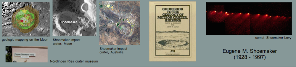


American Geophysical Union AGU 2024

Research on impact geology, geophysics, petrology, and impact cratering
American Geophysical Union AGU 2024
Kord Ernstson, Jens Poßekel, Karel Ventura, and Martin Molnár
Abstract: We report an unusual polymict melt rock megabreccia in the form of an allochthonous non-volcanic megablock within the Tertiary volcanic province of the Bohemian Massif. It is considered a relict of a suspected low-altitude airburst impact.
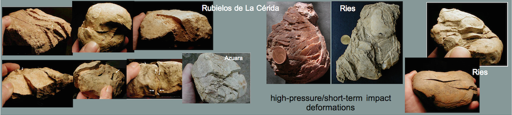
F.M. Claudin and K. Ernstson
Abstract: We report on the mid-Tertiary multiple Azuara impact event (Spain) with the Azuara impact structure and the Rubielos de la Cérida impact basin and the chequered history of their discovery and their place in impact research.
A peer-reviewed journal collection covering all aspects of airbursts and impacts on Earth by Comets and Asteroids – Click the image to enter this new world of impact research.
Under the auspices of the ScienceOpen platform, this new journal provides a publication forum that is arguably unparalleled within the global impact research community. Designed as an open access journal with free access to any size readership, this journal for high quality contributions is a response to what a new report (1/4/2023) in the journal NATURE described as a sharp increase in the number of purely scientific and technical articles in recent decades, with a drastic decline in submitted articles pointing in new, exciting, “disruptive” directions. This development is unfortunately accompanied by increasingly incompetent and partially manipulated peer review processes, for which there is some thought-provoking evidence directly addressed here. What expresses this alarming development better than that at MDPI journals the Editorial Board at Minerals, for example, has 405 members and the Reviewer Board 274 members, and at Geosciences 300 members occupy the Editorial Board and 198 members the Topical Advisory Panel.
This new journal will have a different character, and a detailed introduction and overview (aims and scope, article submission, published articles statistics, peer review processes, and more) is provided by clicking on the image above. A special feature is already added here that the journal also consideres quality posters and iPosters accepted from meetings (e.g. LPSC, AGU Fall Meeting, MetSoc Meeting) for publication in this journal.
The ugly side of Peer Review.
The guest editors of the Special Issue on terrestrial meteoritic impacts and impact structures, Prof. Dr. Kord Ernstson (Editor-in-Chief), Dr. Allen West, Dr. Gerhard Schmidt (Co-Editors) have terminated their collaboration with the MDPI Journal GEOSCIENCES with immediate effect (with confirmation from MDPI). The reason is intolerable and ugly manipulation of the peer review process for research articles submitted for the special issue. Thereafter, unchallenged by Geosciences, external intervention (almost certainly from the so-called narrower “impact community”) occurred in the virtually positively terminated review process of several articles with a final REJECT by the Geosciences Academic Editorial, without a single word of notice to us as responsible editors of the Special Issue.
This practice, massively violated against all scientific ethics (which MDPI apparently holds so high), has become intolerable for us. The four research articles already announced for the Special Issue are in preparation for a more honest publication organ.
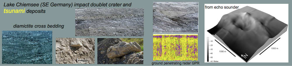
People experienced the prehistoric Chiemgau meteorite impact – geoarchaelogical evidence from southeastern Germany: a review
Barbara Rappenglück, Michael Hiltl, Jens Poßekel, Michael Rappenglück, Kord Ernstson
Mediterranean Archaeology and Archaeometry, 23, No. 1, 209-234, 2023.
http://maajournal.com/Issues/2023/Vol23-1/8_Rappengluck_et_al_23(1).pdf (full article free open access)
Abstract. – Archaeological sites undoubtedly destroyed by a meteorite impact had not been identified so far. For such a proof, both a meteorite impact and its definite effects on an archaeological site would have to be evidenced. This review article reports on geoarchaeological investigations, involving mineralogy, petrography, and geophysics, which established evidence that two prehistoric human settlements have been affected by the Late Bronze Age/Early Iron Age (ca. 900-600 BC) Chiemgau meteorite impact in southeastern Germany. One site, the Mühlbach area, was affected by the ejecta from the 600 m Ø-Tüttensee crater, one of the largest craters in a crater strewn field measuring about 60 x 30 km. At the other site, Stöttham close to Lake Chiemsee, the catastrophic layer of the impact was found embedded in the archaeological stratigraphy of a settlement, which had been repeatedly occupied from the Neolithic to the Roman era. At both sites, artifacts have become components of impact rocks, establishing a hitherto unknown form of an impact rock, an artifact-in-impactite. The immediate coexistence of rocks, which exhibit impact-diagnostic shock metamorphism, with relicts of metallic artifacts, as encountered in finds from Stöttham, are unprecedented evidence of human experience of a meteorite impact.
Pingos and mardels: high-resolution digital terrain models suggest meteorite impact craters in addition to permafrost, sinkhole and dead-ice formation models.
Kord Ernstson1 and Jens Poßekel2
Abstract. – With the meanwhile widely available data of Digital Terrain Models (DTM) with extremely high resolution of the bare terrain surface, vertically and horizontally, down to the decimeter and centimeter range and freed from buildings and any vegetation, completely new possibilities have opened up in the geosciences, which entail paradigm shifts in established ideas and textbook wisdom. Such a paradigm shift is especially indicated in ice age research and more generally in the still open discussion of the formation of smaller terrain forms in the manner of general and diverse depressions. With the new possibilities of the DTM a new “contender” has entered the discussion, which was already considered as a cause sporadically in former times, since relatively short time with the extreme terrain resolution of the DTM has led to completely new ways of consideration. This article reports about it with the finding that impact craters may be the more reasonable explanation for previously assumed pingos, mardels in the general sense, and dead ice holes.
Keywords: Pingo, mardel, sinkhole, dead ice hole, meteorite crater, impact crater strewn field, impact airburst
____________________________________________
1University of Würzburg, D-97074 Würzburg, Germany, kernstson@ernstson.de; 2Geophysik Poßekel Mülheim, Germany, jens.possekel@cityweb.de.
1 Introduction
Pingos are mounds of earth formed in permafrost. The interior of the mound consists of an ice core, and they have a circular or oval shape and can reach a diameter of up to several hundred meters and a height of up to several dekameters. When the ice core melts, the pingo collapses and forms a depression in the ground called a pingo ruin. A common explanation of ice core formation is artesian rising warmer waters in the permafrost, which freeze there and are successively pushed further and further up as a massive core.
Continue reading “New Article: Pingos, Mardels and Meteorite Impact Craters”
Comment on
Brenker, F.E., Junge, A.. (2023) Impact origin of the “Domaine du Meteore”-crater, France. Compelling mineralogical and geophysical evidence for an unrecognized destructive event in the heart of Europe. – 54th LPSC, #1910. www.hou.usra.edu/meetings/lpsc2023/pdf/1910.pdf
by Kord Ernstson, University of Würzburg, Germany
Abstract . – The claim that the vineyard crater is the fourth proven impact crater in Western and Central Europe after Rochechouart, Ries, and Steinheim is a fundamental scientific misstatement because the impacts and impact crater.strewn fields (Chiemgau, Saarland, Czech Republic) that have been researched and published for 15 years with all proven and scientifically accepted impact criteria is hushed up. The Canadian Earth Impact Database is basically denied the legitimacy to asssess and comment with pros and cons on scientific work and publications.
At this year’s Lunar & Planetary Science Conference there is the above quoted abstract contribution by the authors F.E. Brenker and A. Junge from the University of Frankfurt. The relatively small crater with a diameter of about 200 m has already been discussed as a meteorite crater for more than 70 years by different authors, but this has always been discarded. The present contribution from Frankfurt describes a new investigation, which establishes the meteoritic origin according to known impact criteria. The abstract article convincingly describes the impact origin with topographic, geophysical, and mineralogical findings and evidence, and arouses curiosity for a comprehensive conference poster and article that may be planned.
The article is commented on for a different reason. It begins by stating that the French crater is significant in that it joins the few three impact craters so far proven in Western and Central Europe, namely
Continue reading “Domaine du Météore crater, France – Comment on the LPSC 2023 article”
Comment
on the EPSC 2022 Meeting abstract paper of Juan Antonio Sánchez Garrido, Jens Olof Ormö, Carl Alwmark, Sanna Alwmark, Gabriel Zachen, Robert Lilljequist, and Sebastián Tomás Sánchez Gómez : A probable impact structure in Betic Cordillera, Almeria, SE Spain.
and its relation to the Azuara impact event comprising the Azuara impact structure and the Rubielos de la Cérida impact basin (Spain)
by Kord Ernstson1 and Ferran M. Claudin2
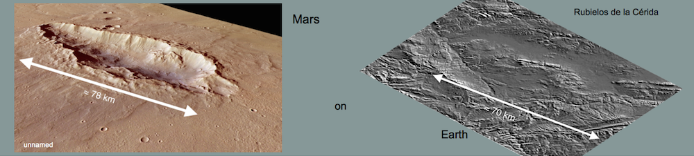
Abstract.- In an abstract paper presented at the EPSC 2022 Granada (Europlanet Sociey) the authors above from Spain, Sweden and Denmark report about research on what they called the first impact structure in Spain. Numerous media reports about this “first impact structure in Spain” immediately after the meeting suggest that this formulation was directly put into the world by the authors in a press release and that they thereby commit a bad falsification by not mentioning the worldwide prominent gigantic Azuara impact event with the 40 km-diameter Azuara impact structure and the Rubielos de la Cérida impact basin measuring approx. 80 km x 40 km, which has been established for more than 20 years, and, hence, declaring it as non-existent. We report here on key stages of the study of these really first Spanish impact structures since 1985, comment this massive expression of scientific dishonesty, and bring for all less informed and the media-believing people a compilation of the innumerable extremely easily in the Internet accessible contributions in English, Spanish and German, which leads the statement of the alleged first impact structure in Spain ad absurdum.
____________________
1 University of Würzburg, 97074 Würzburg (Germany); ernstson@ernstson.de; 2 Associate Geological Museum Barcelona (Spain); fclaudin@xtec.cat
Keywords: Azuara impact event, Azuara impact structure, Rubielos de la Cérida impact basin, Spain, Almería impact, manipulation of science
1 Introduction
At the recently concluded EPSC 2022 meeting in Granada, authors Juan Antonio Sánchez Garrido, Jens Olof Ormö, Carl Alwmark, Sanna Alwmark, Gabriel Zachen, and Sebastián Tomás Sánchez Gómez (University of Almería, Centro Astrobiología, Madrid, Lund University (Sweden), and University of Copenhagen) and Eurogeologist Robert Lilljequist had an abstract contribution entitled “A probable impact structure in Betic Cordillera, Almeria, SE Spain.”
The “probable impact” of the paper is based on a polymict breccia clast and three quartz grains with weak PDF but without any confirmation of cristallographic orientation, and with no further shock metamorphism. After 15-20 years of their research, no word on regional geology, no geophysics, no shatter cones, no impact melt, no impact glasses, no ejecta deposits, no drilling on the presumed impact basement.
We do not want to question the possible evidence of an impact in Almería. What we characterize as dirty science is the fact that immediately after the meeting a large number of media are writing in unison about the FIRST impact structure in Spain:
— First probable impact crater discovered in Spain (phys.org).
— Researchers believe they have discovered the first impact crater in Spain in Almería (time.news).
–First Probable Impact Crater Discovered in Spain (europlanet society.
–First probable impact crater discovered in Spain (Alphagalileo).
— Researchers believe they have discovered the first impact crater in Spain in Almería (Chicago Today).
— First Probable Impact Crater Discovered in Spain (Toptek News).
— Discovered the first possible impact crater by meteorite in Spain (spainsnews) — Discovered the first probable impact crater in Spain (daily-how)
… and many others.
This mass of reports about the FIRST Spanish impact structure has probably been initiated by the media by a press release of the authors of the abstract, and this is exactly what we call dirty science that these authors talk against better knowledge and rather infamously about the FIRST impact structure in Spain. We stand by the word “infamously”, which we will justify in detail below.
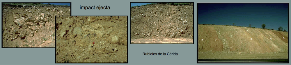
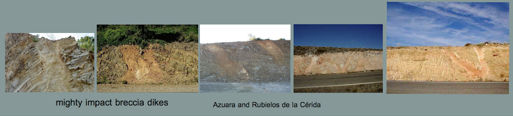
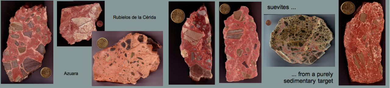
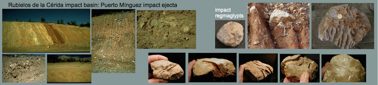
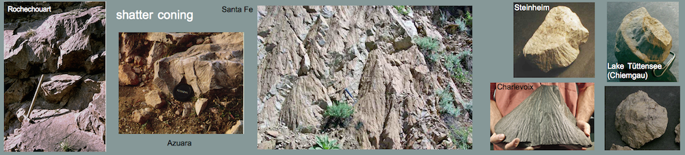
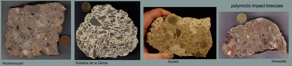
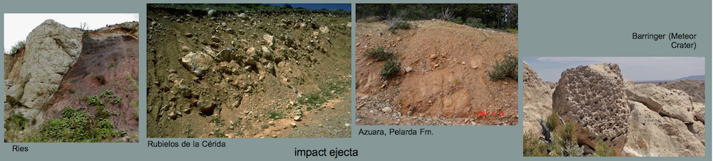
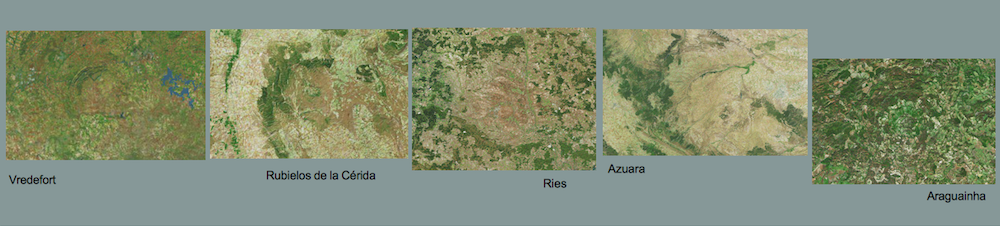
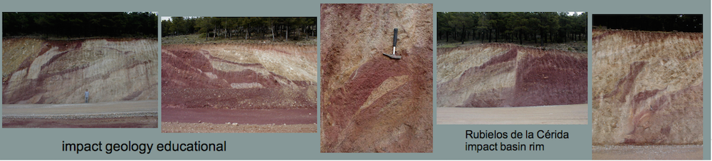
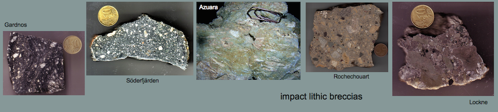
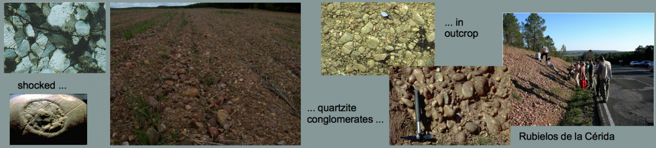
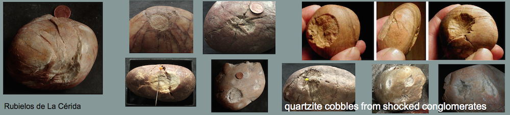
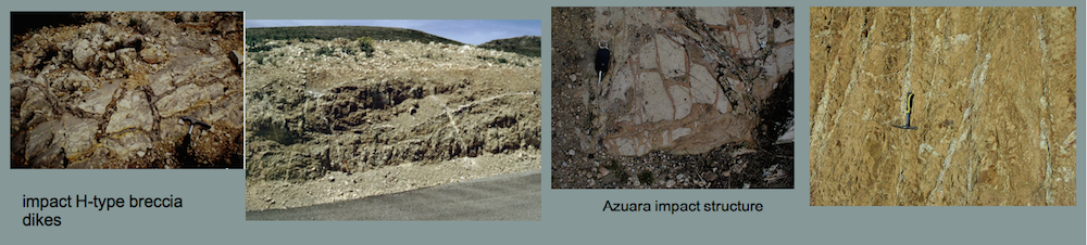
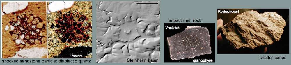
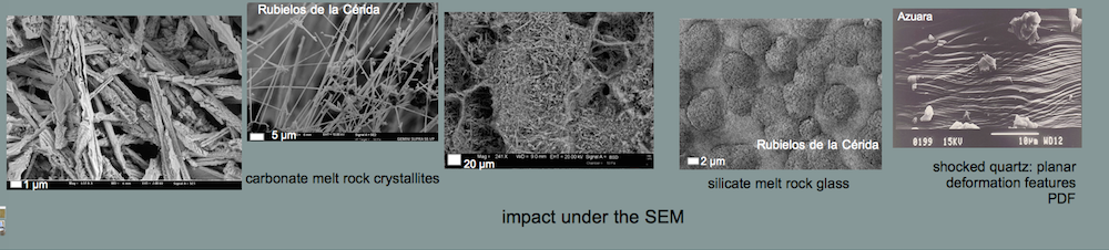
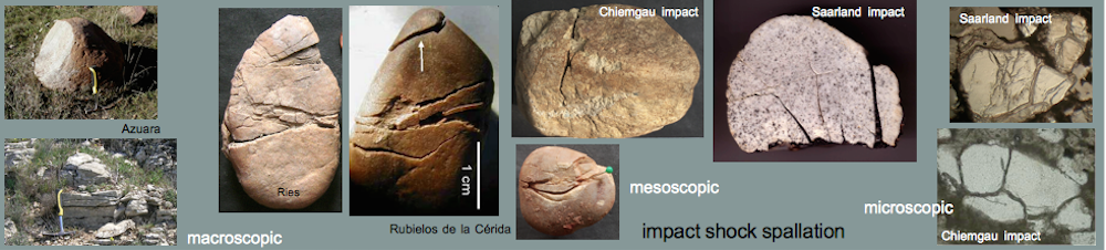
2 The current state of research of the established Azuara multiple impact event with the Azuara impact structure and the Rubielos de la Cérida impact basin in the provinces of Zaragoza and Teruel (Spain)
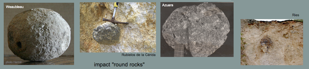
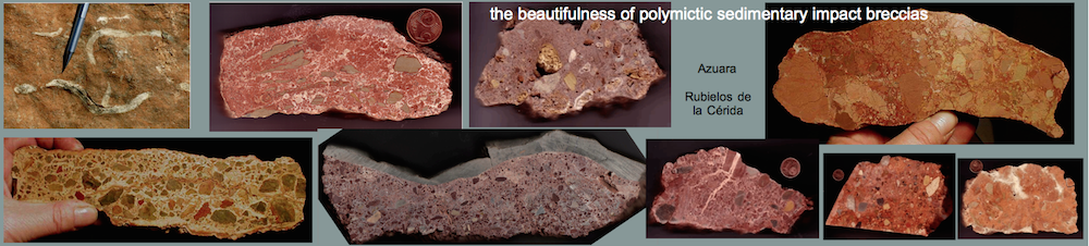
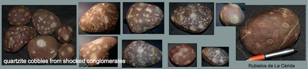
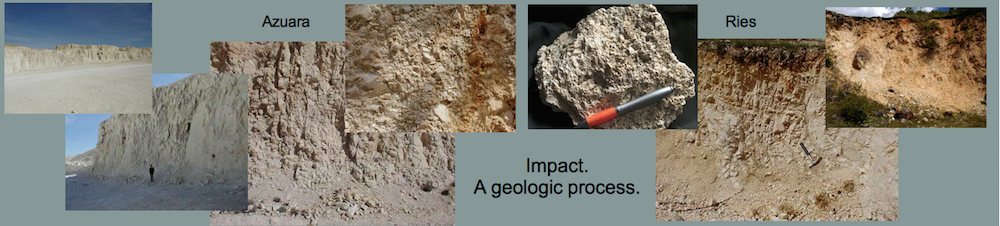
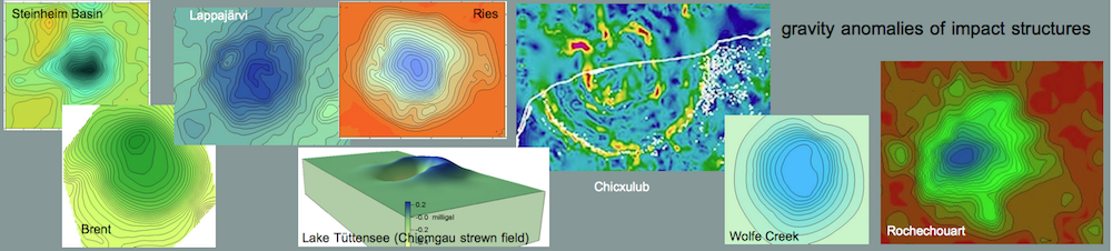
Since the first publication about the impact origin of the Azuara impact in 1985 in Earth and Planetary Science Letters followed by a dozen of diploma and doctoral theses, and the publications in 2001 and 2002 on the meanwhile established Azuara and Rubielos de la Cérida twin impacts, a host of impact-typical proofs have been published having made this Spanish impact to one of the most prominent impact events worldwide. The importance is underlined by the very easy access (frequently simply by car) to a hundred of outcrops or more, where the impact can be experienced up close, and spectacular samples can be obtained effortlessly – in contrast, for example, to the Chicxulub impact, where comparably significant samples are only tangible via kilometer-deep drillings. We list the scientifically most important findings:
— a roughly 40 km-diameter Azuara impact structure with roundish morphological signature
— a roughly 80 km x 40 km-size Rubielos de la Cérida multiple impact basin with impressive elongated basin morphology and a significant central uplift chain
— geophysical, gravity and geomagnetic, signature
In both structures:
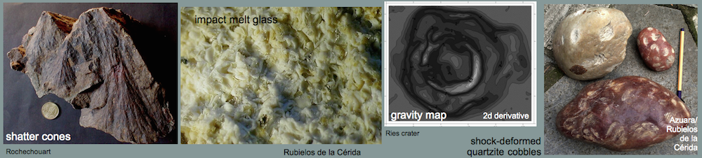
— in part brilliantly exposed impact “tectonics” of impressive folds and faults, also documenting the everywhere occurring indication of tensile impact shock rarefaction signature
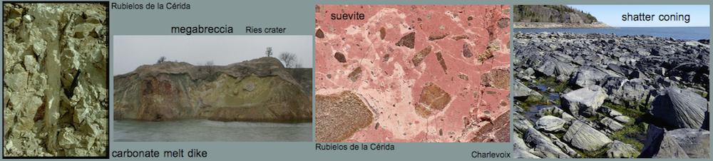
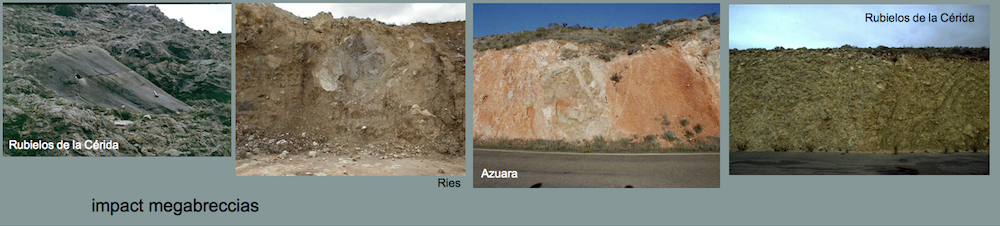
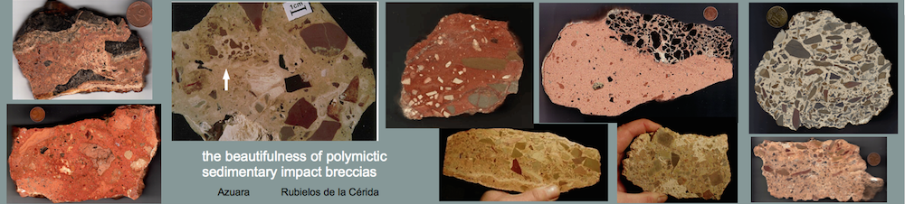
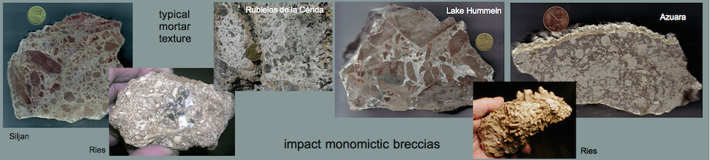
— a host of impact monomictic and polymictic impact breccias everywhere frequently showing multiple breccia generations typical of impact
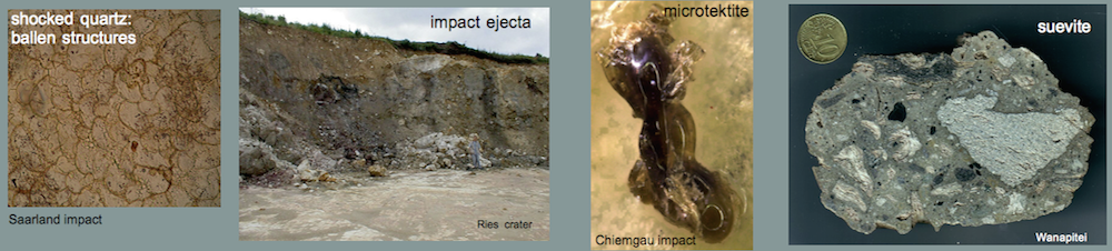
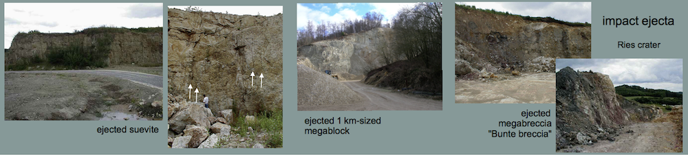
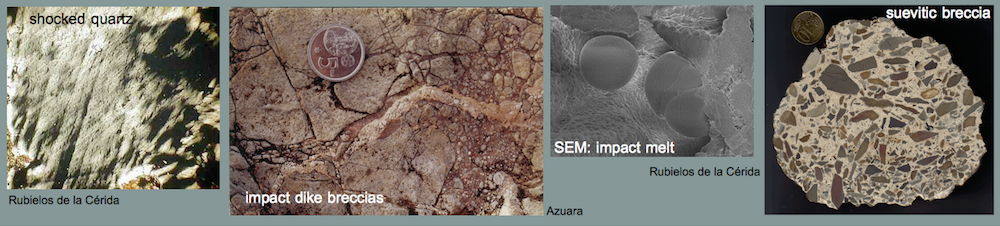
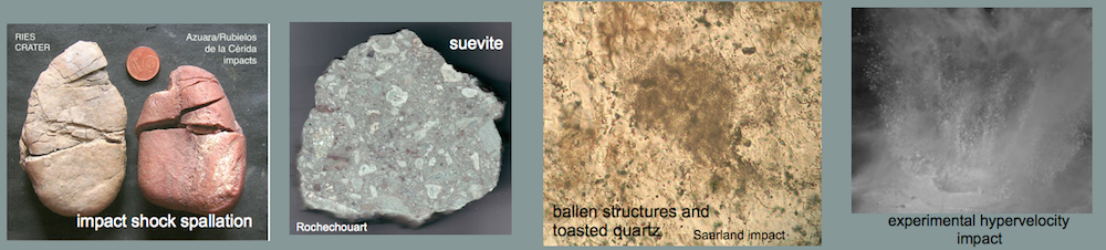
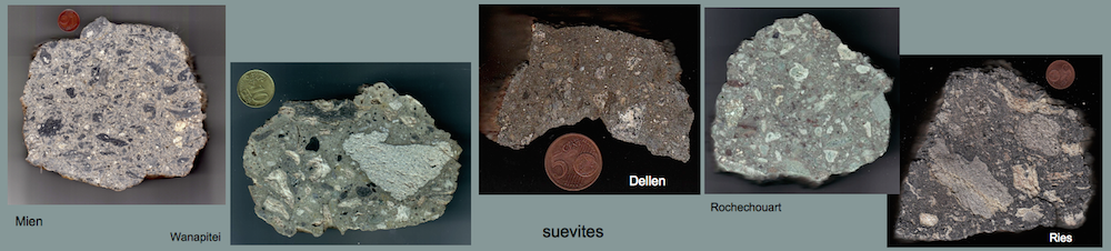
— extended suevite breccias
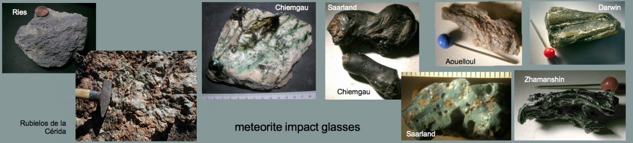
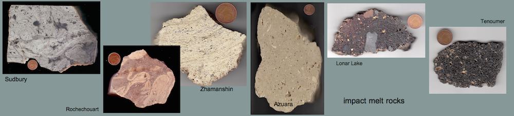
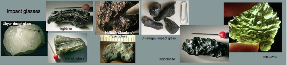
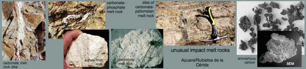
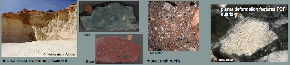
— well-known and unusal impact melt rocks and glasses
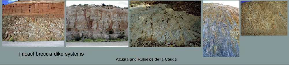
— a host of monomictic and polymictic breccia dikes forming dike generations and extended breccia dike systems not known in this impressive concentration from other impacts worldwide
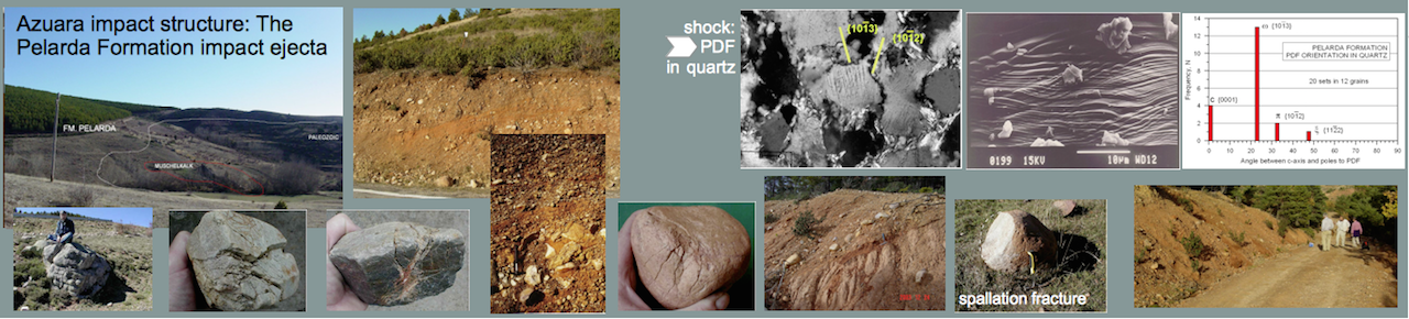
— a host of impact megabreccias (the large Pelarda Fm. ejecta deposit – Azuara; the large Puerto Mínguez ejecta deposit – Rubielos de Cerida; the prominent megabreccias of Barrachina, Belchite/Almonacid de la Cuba and Herrera)
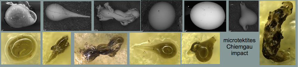
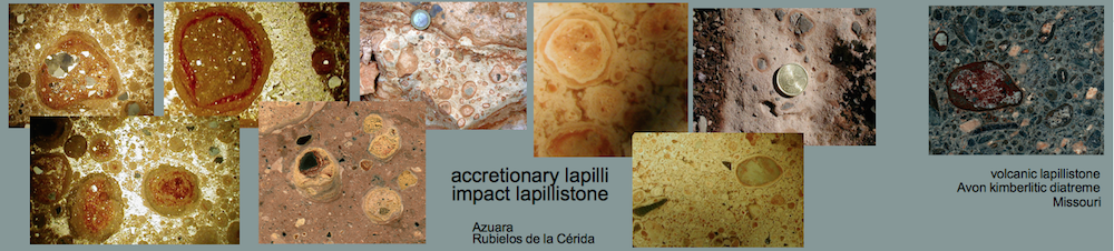
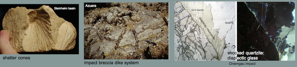
— abundantly exposed accretionary lapillistones
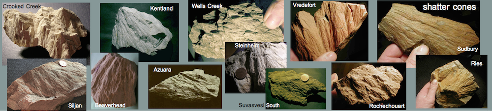
— shatter cones
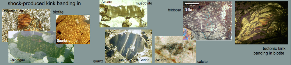
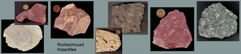
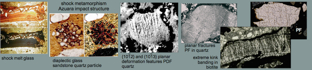
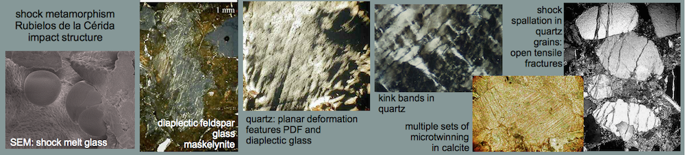
— strong shock metamorphism: shock melt, diaplectic glass from quartz and feldspar; planar deformation features PDFs in quartz and feldspar, multiple sets of planar fractures PFs in quartz, multiple sets in strongly kinked quartz and mica, multiple sets of microtwinning in calcite
Proofs for all these impact-realated features are published and are easily accessed on clicking the vast of Internet contributions listed below.
3 Lists of early and recent publications on the Spanish impact structures
3.1 WIKIPEDIA
https://en.wikipedia.org/wiki/Azuara_impact_structure
https://es.wikipedia.org/wiki/Estructura_de_impacto_de_Azuara#:~:text=La%20estructura%20o%20cr%C3%A1ter%20de,el%20centro%20de%20la%20estructura.
https://de.wikipedia.org/wiki/Datei:Azuara-impact-structure-PDF_histogram.jpg
https://commons.wikimedia.org/wiki/Category:Rubielos_de_la_C%C3%A9rida_impact_structure
https://en.wikipedia.org/wiki/Rubielos_de_la_C%C3%A9rida_impact_structure
… and several dozens, maybe more than 100, of WIKIPEDIA URLs for Google “azuara impact” and Rubielos de la Cérida impact” and “Spain impact structures”.
3.2 WEBSITES. pertinent
Rubielos de la Cérida impact structure
Impact structures in Spain and related topics
Estructura de impacto de Azuara
La cuenca de impacto de Rubielos de la Cérida
Las estructuras de impacto en España y temas relacionados
Das Rubielos de la Cérida-Impaktbecken – ein Teil der Azuara/Rubielos de la Cérida Kraterkette
https://www.researchgate.net/profile/Kord-Ernstson
33 publications about the Spanish impact structures Azuara and Rubielos de la Cerida addressed in Researchgate
2 Research Projects on the Spanish Azuara and Rubielos de la Cérida impacts
https://www.researchgate.net/profile/Ferran-Maria-Botines/research
22 publications about the Spanish impact structures Azuara and Rubielos de la Cerida addressed in Researchgate
2 Research Projects on the Spanish Azuara and Rubielos de la Cérida impacts
3.4 Recent publications (2012-2022) of Ernstson and Claudin on the Spanish impact event, the Azuara impact structure and the Rubielos de la Cérida impact basin.
“Earth’s Impact Events Through Geologic Times”: Comment on Schmieder & Kring article in Astrobiology
Daroca thrust (Iberian Chain, Spain) and the Azuara impact structure -the controversy continues.
Impact deposit at the Moneva reservoir, Azuara impact structure (Spain)
Azuara and Ries impact structures: The Daroca thrust geologic enigma – solved?
3.5 A few early publications
Ernstson, K., Schüssler, U., Claudin, F., Ernstson, T., 2003: An Impact Crater Chain in Northern Spain. – Meteorite, 9, 35-39.
Claudin, F. and Ernstson, K. (2003): Geologia planetaria y Geologia regional: el debate sobre un impacto múltiple en aragón. Enseñanza de las ciencias de la Tierra, vol 11, nº 3, pp 202-212.
Schüssler, U., Hradil, K., Ernstson, K.2002: Impact-related melting of sedimentary target rocks of the Rubielos de la Cérida structure in Spain. Berichte der Deutschen Mineralogischen Gesellschaft, Beiheft 1 zum European Journal of Mineralogy, Vol. 14, S. 149.
Ernstson, K., Claudin, F., Schüssler, U., Hradil, K., 2002: The mid-Tertiary Azuara and Rubielos de la Cérida paired imapct structures (Spain). Treb. Mus. Geol. Barcelona, 11, 5-65.
Ernstson, K., Rampino, M.R. & Hiltl, M.: Cratered of cobbles in Triassic Buntsandstein conglomerates in NE Spain: Shock deformation of in-situ deposits in the vicinity of large impacts. Geology, v. 29, no.1, 11-14, 2001
Hradil, K., Schüssler, U., and Ernstson, K.: Silicate, phosphate and carbonate melts as indicators for an impact-related high-temperature influence on sedimentary rocks of the Rubielos de la Cérida structure, Spain. Abstracts, 6th ESF IMPACT workshop, Impact Markers in the Stratigraphic record, pp. 49-50, 2001.
Ernstson, K., Rampino, M.R., and Hiltl, M.: Shock-induced spallation in Triassic Buntsandstein conglomerates (Spain): an impact marker in the vicinity of large impacts. Abstracts, 6th ESF IMPACT workshop, Impact Markers in the Stratigraphic record, pp. 25-26, 2001.
Ernstson, K., Claudin, F., Schüssler, U., Anguita, F, and Ernstson, T.: Impact melt rocks, shock metamorphism, and structural features in the Rubielos de la Cérida structure, Spain: evidence of a companion to the Azuara impact structure. Abstracts, 6th ESF IMPACT workshop, Impact Markers in the Stratigraphic record, pp. 23-24, 2001.
Ernstson, K., Rampino, M.R., Anguita, F., Hiltl, M., and Siegert, I.: Shock deformation of autochthonous conglomerates near the Azuara impact structure, Spain: Geological Society of America Abstracts with Program, v. 31, p. A-122., 1999.
Ernstson, K. & Claudin, F.: Pelarda Formation (Eastern Iberian Cains, NE Spain): Ejecta of the Azuara impact structure. – N.Jb.Geol.Paläont.Mh., 1990, 581-599, 1990.
Müller, H. & Ernstson, K.: Curved joint sets: Indication of impact-induced fracturing. – In: Mechanics of Jointed and Faulted Rock, H.P.Rossmanith, ed., 257-263, Balkema, Rotterdam 1990.
Ernstson, K.: Looking for Geological Catastrophes: The Azuara Impact Case. – In: Extinción y registro fósil (Extinction and the fossil record, E. Molina, ed.), Cuadernos Interdisciplinares No. 5, 31-57, SIUZ, 1994.
Ernstson, K. & Fiebag, J.: The Azuara impact structure (Spain): new insights from geophysical and geological investigations. – Int. J. Earth Sci., 81/2, 403-427, 1992.
Ernstson, K., Feld, H. & Fiebag, J.: Impact hypothesis for the Azuara structure (Spain) strengthened. – Meteoritical Society Meeting, Newcastle upon Tyne, 1987. – Meteoritics, 22, 373, 1987.
Ernstson, K., Hamman, W., Fiebag, J. & Graup, G.: Evidence of an impact origin for the Azuara structure (Spain). – Earth Planet. Sci. Let., 74, 361-370, 1985.
4 Discussion
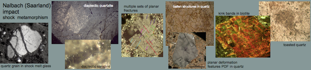
The discovery and scientific treatment of the Spanish impact structures has a long history of about 40 years. In 1981, the first field work began in the province of Zaragoza near the village of Azuara, which, together with initial mineralogical studies at the University of Würzburg, resulted in the first publication in Earth and Planetary Science Letters in 1985. As evidence for the impact was considered already at that time the unmistakable finding of PDFs in quartz, for which the spectrum with the typical crystallographic directions of the shock metamorphism from breccias (Fig. 1) of the also already morphologically addressed Azuara structure. Two years later in 1987, Azuara was already listed as a proven impact structure in the book of Richard A.F. Grieve TERRESTRIAl IMPACT STRUCTURES “Annual Review of Earth and Planetary Sciences” and subsequently included in the Canadian Impact Database under the direction of R.A.F. Grieve as a proven impact. R.A.F. Grieve will be mentioned also later. Further articles on the Azuara impact followed in international journals. This remained generally accepted knowledge in the impact community. Until 1996.
In an abstract article of the LPSC Langenhorst & Deutsch (1996) claim [The Azuara and Rubielos structures, Spain: Twin impact craters or Alpine thrust systems? TEM investigations on deformed quartz disprove shock origin (abstract). Lunar and Planetary Science, v. XXVII: 725-726] that there is no evidence of shock in the Azuara impact structure. They base this claim solely on the TEM analysis of a sample given to them by one of the present authors (K.E.). However, this sample did not come from the Azuara structure at all, but was taken far outside the structure. Furthermore, Langenhorst & Deutsch had not taken note at all of the exact description (given to them by K.E.) of the sample, which shows basal deformation lamellae, but not at all planar deformation features (PDF). Although K.E. had insistently pointed out the elementary mistake to the authors, Langenhorst & Deutsch did not withdraw the contribution, which would have been possible. The two authors were then accused of scientific dishonesty.
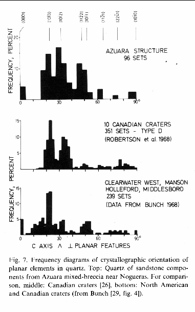
Fig. 1. PDF diagram from the first publication 1985 on the Azuara impact proving impact shock deformation.
The consequences continue to this day. This abstract was promptly the trigger of the manifold unpleasant campaigns especially by geologists of the University of Zaragoza and the Spanish Geological Survey, who vehemently denied an existence of the impact structures. This was understandable especially against the background that practically all these geologists had made and published their thick doctoral theses exactly in the impact areas, without recognizing such significant eye-catching geological impact findings. Such controversies are known from the whole impact research.
A new phase of the fight against the huge Spanish impact event started around the year 2000. An article by Ernstson, K., Claudin, F., Schüssler, U., Hradil, K.: “The mid-Tertiary Azuara and Rubielos de la Cérida paired impact structures (Spain)”, submitted to the journal Earth and Planetary Science Letters, was rejected by the peer reviewers C. Koeberl and R.A.F. Grieve, by Koeberl with partly absurd falsifications of the text statements. In an adapted 60 pages version, this article was then published in 2002 in the series of the Geological Museum of Barcelona (see above), without this work ever being cited by the Spanish opposing authors.
At the 2001 meeting of the 6th ESF IMPACT workshop in Granada, Impact Markers in the Stratigraphic Record, four poster papers by different authors (cited above) on the Azuara and Rubielos de la Cérida impacts were presented. At a subsequent associated discussion, Dr. Therriault of the Canadian Geological Service had presented her written analysis, initiated by Prof. Anguita (Madrid) and Dr. Rampino (New York), on 31 pages, of a large number of shocked quartz grains from Azuara impact breccias with all the strictly known features of PDFs: Therriault, A. (2000): Report on Azuara, Spain, PDFs, 31 p. In the session she oddly enough presented the PDFs as uncertain, apparently on instruction “from above”. Her fantastically good work can still be consulted today.
At that time there was the next cut. The Canadian Impact Database from the Survey moved to the University of New Brunswick under the new leadership of John Spray. And suddenly the Azuara structure had disappeared from the database and has not been reinstalled in it to this day, not to mention the magnificent multiple Rubielos de la Cérida impact basin, which has also never before been included in the Earth Impact database despite overwhelming published impact evidence. We estimate that in this database over 90% of the impact structures considered proven there do not have this extent of impact evidence of geology, geochemistry, mineralogy-petrography, geophysics and schock metamorphism as is the case for the great Spanish impact event. Characteristic of John Spray’s odd understanding of science: In a written inquiry Ferran Claudin asked him why the Azuara structure formerly established as a proven impact had been eliminated and disqualified from the data base and why also Rubielos de la Cérida despite overwhelming impact evidence has not been recorded. Moreover, Ferran offered to send him reprints of all published articles on the impacts. John Spray wrote back that Ferran were free to do it but that he, John Spray, would not read the articles.
According to the Database Website, major contributions to the development of earlier versions of this database have been made by Richard Grieve and James Whitehead. This is a circumstance that leaves us perplexed that Richard Grieve, who was the first important impact researcher to qualify the Azuara impact as confirmed and proven and absolutely worthy for the Canadian database until 2001 (rightly so), tolerates to this day, despite his closeness to the database, that both Azuara and Rubielos de Cérida are swept under the table by a small clique from the so-called impact community as impact-wise very questionable and not confirmed, still after 40 years of research.
And this is exactly the point with which we want to close the discussion and return to Almería. Because on this concealment of the Spanish Azuara and Rubielos de la Cérída impacts in the Earth impact database until today, in the entire newer Spanisch geological literature including newest text books, the Azuara impact event is nowhere quoted, also not with any counterarguments. And again and again reviewers of impact journal articles demand from the authors that references to the Spanish impacts are taken out with the reason that the Earth Impact Datenbase does not recognize them. Against this background, the Almería authors have of course a carte blanche to publish their assumed crater as the first one in Spain.
5 Conclusions
The first conclusion is not directly about science, but about the media and their reporters who trumpet questionable “messages” without the slightest researche. Apart from the Internet articles listed at the beginning, the inglorious article by Lydia Lawson in techupdate should be mentioned in particular. Although on the one hand she meritoriously deals critically to skeptically with the message about the Almería structure, on the other hand she refers in a single sentence to the discussion about the Azuara impact in 1997 (i.e. 25 (!) years ago) and to the fact that an impact formation is excluded today. This is clearly pretty bad science journalism. We probably hope in vain that the authors of the Web papers mentioned here will present things correctly and apologize to their readers for the dubious “snap judgments”.
Second: Around the early 2000’s, when Azuara and Rubielos de la Cérida had long been treated as print and extensively on the Internet, a strong desire to do their geological fieldwork for their master’s and doctoral exam papers arose among many students of geology at Spanish universities who were, of course, already well informed via the Internet about the exciting and forward-looking research being done there. We have been told by the University of Madrid that students who expressed this wish were told in no uncertain terms: If you ever want to make a career in geology, just don’t do your exam papers in these structures.
We fear that this has not changed to this day; we have not become aware of any such work, although there are still a vast number of geologically-mineralogically highly attractive topics awaiting further work. We wonder if this deplorable behavior within the “impact community” (we will refrain from naming well-known persons and names) makes those responsibles aware that they are not only causing and have caused immeasurable damage to impact research in general, but also are preventing young people eager to produce new significant research results in an exciting field from doing so. Irresponsible that is.
Click the ePoster – Galery: Meteoritical Society Meeting Glasgow 2022 – See details by enlarging the PDF.
Anonymous reviewers from the LPI have rejected the following two abstracts submitted to the 13th Planetary Crater Consortium 2022 Meeting:
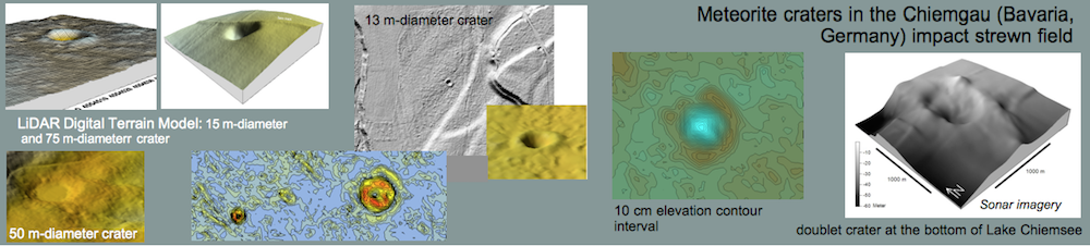
A Probable Holocene Meteorite Crater Strewn Field in Lower Franconia (Germany): Evidence from Digital Terrain Models and Geophysical Surveys (GPR, Electrical Imaging, Geomagnetics)” by J. Poßekel, G. Schulz-Hertlein, T. Ernstson & K. Ernstson
The reason for the rejection by the LPI can be clicked.
Click to enlarge.
Pingos and Mardels: High- Resolution Digital Terrain Models Suggest Meteorite Impact Craters in Addition to Permafrost, Sinkhole and Dead-Ice Formation Models” by K. Ernstson & J. Poßekel
The reason for the rejection by the LPI can be clicked.

Click to enlarge.
The reader of these reasons may make his/her own thoughts.
Those who read the justifications will have to conclude that the LPI reviewers have obviously not yet arrived in the 21st century and are not (or do not want to be) familiar with the latest impact literature.