

Taklamakan Desert (China): a mega-impact structure?
Kord Ernstson
University of Würzburg, 97074 Würzburg (Germany), kernstson@ernstson.de
October 2020
Abstract.- A Google Earth-based morphological analysis of the Taklamakan Desert in the north of the Himalayas shows characteristics of a 1000 km mega-sized impact structure with an elliptical basin and a pronounced elliptical morphological rim. The elliptical structure may possibly have originated from the thrust of the Indian plate and the Himalayas. A gravity anomaly corresponds with the structure. More impact evidence is not known so far.
Key words: Taklamakan Desert, China, impact structure, gravity anomaly, Indian plate
A pdf full article may be downloaded here.
__________________________________________
1 Introduction
A common internet user spotted the area while viewing the NASA WorldWind Demo [website:- worldwind.earth/explorer] and mailed screenshots highlighting the area to the author with the following observation: “I have pointed out what I think are the places of the huge impact that could have affected life on Earth. These are not identified in the Earth Impact Database. The bigger spot is the Taklamakan desert in western China and the smaller one is in western Mongolia. Only the southern curve of the huge area, which is the southern curve of the Himalayas, coincides with a tectonic plate boundary. The reason for the formation of the rest of the huge area (the mountainous regions) is still not properly known.
Familiar with regular requests from all over the world about possible large and small impacts that should be visible in the satellite imagery, skepticism prevailed. Nevertheless, the region with a focus on the large structure in China was brought to the Monitor and surprisingly Google Earth presented the structure quite impressively (Fig. 1).
This was followed by a use of the possibilities that Google Earth meanwhile offers, with a result worth thinking about, but of which it is already emphasized that this is a kind of scientific game with unclear outcome and not a recommendation to the Earth Impact Database.
2 Morphology – Image processing
The Taklamakan Desert or Tarim River Basin forms a roughly elliptical plane, which, apart from a river opening to the east, is surrounded by steeply rising mountain ranges (Fig. 1-3). According to the geological sketch map of China, the basin plane is occupied by Quaternary sands with some marginal Tertiary (Fig. 3).
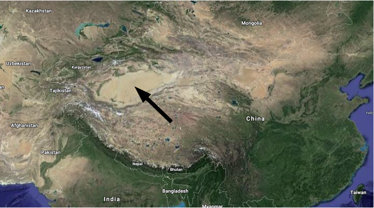
Fig. 1. Location map for the desert region under discussion (Google Maps).
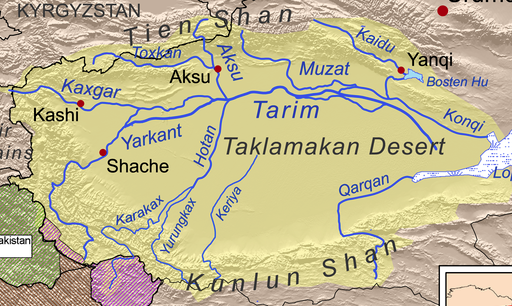
Fig. 2. The Tarim River in the Taklamakan Desert. The rivers in the basin are dry most of the time. Source: Wiki Commons.
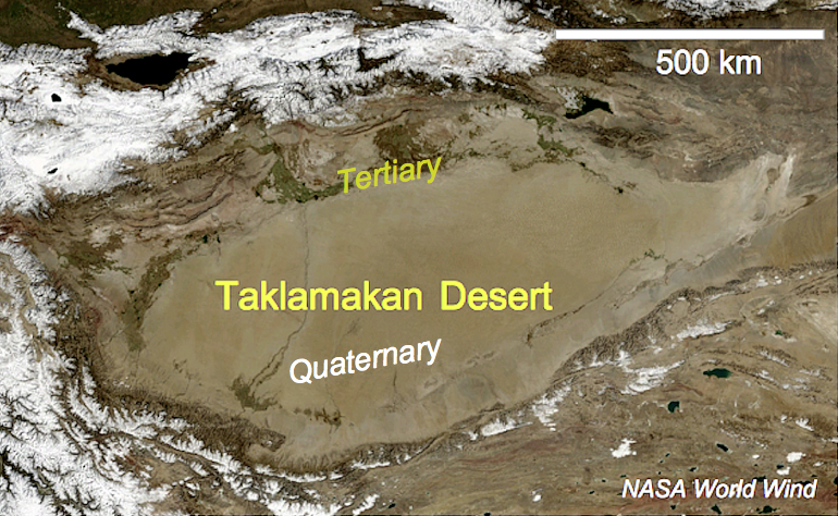
Fig. 3. The desert from up close. Geology: Quaternary in the basin and Tertiary rim.
For a closer examination of the basin, a total of 16 radial height profiles were taken in Fig. 4, which converge to approximately the center of the structure. Sections of the height profiles that cross the rim of the structure are shown in Fig. 5.
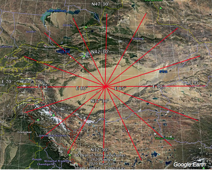
Fig. 4. 16 radial profiles roughly centered on the middle of the elliptical structure.
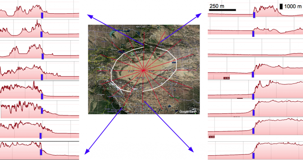
Fig. 5. Topographic profiles from Google Earth with suggested rim of the structure. Sections of the radial profiles focusing to the center have been transformed to parallel traces.
In another illustration in Fig. 6, sections of adjacent profiles were superimposed on each other. They show that in many cases a good fit exists over hundreds of kilometers, which explicitly emphasizes the morphologically excellent rim of the basin.
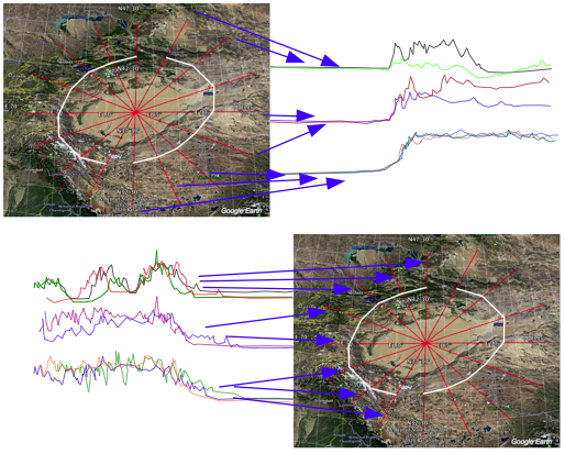
Fig. 6. Superposition of traces of the morphological profiles in Fig. 4. showing in part remarkable fittings.
If the rims marked in Fig. 5 are transferred to the Google Earth map, they form an almost perfect ellipse apart from a gap to the east (Fig. 7). A subparallel smaller ellipse, which mainly follows the valley of the Tarim River in the north (Fig. 2), may also be structural, which will be discussed further below.
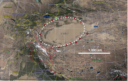
Fig. 7. Elliptical rim of the structure matching the blue marks in Fig. 4.
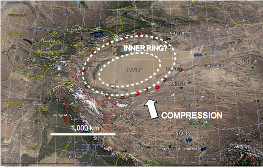
Fig. 8. Outer elliptical rim (Fig. 7) and possible inner ring of the structure.
3 Gravimetry
In Fig. 9 a rectangle is marked in a section of the Bouguer gravity map of China, which encloses the basin. In this section the isolines were digitized, from which a new gravity map was created for further processing (Fig. 10).
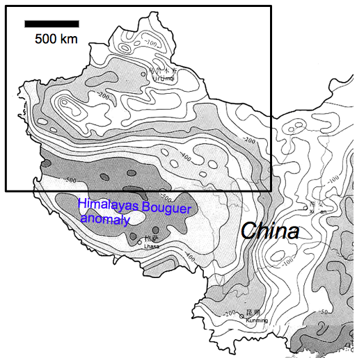
Fig. 9. Digitized section of the Bouguer gravity map of China. Source: Gifex [1].
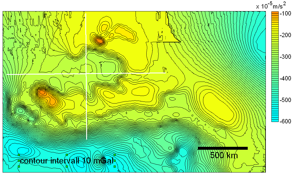
Fig. 10. The Bouguer gravity anomaly map from digitizing the isogals in Fig 9. Note that Kriging extrapolates to the enclosing rectangle. Extraction of gravity profiles along the white lines (Fig. 12).
In the gravity map in the redesigned color representation (Fig. 10), the large negative gravity anomaly of the Himalayas is followed to the north by another, relatively negative anomaly that could be related to the Taklamakan Basin in terms of shape and gradients. A common method in gravimetry to extract local gravity distributions is to construct and subtract a regional trend field from the data, which is done here and shown in Fig. 11. A limitation is that the regional field only forms a very small frame around the local residual field anomaly and adds data artificially generated by extrapolating the Kriging. Consequently, the regional field in Fig. 11 also contains some parts of the local field. As shown in Figure 11, the residual field computation has closed the negative anomaly more tightly and slightly twisted it by a ring of relatively positive anomalies.
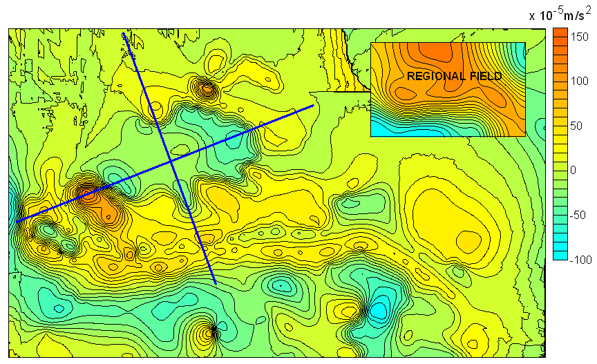
Fig. 11. The gravity residual field after removal of a regional field and lines for drawn gravity profiles (Fig. 12).
From both the original gravity field in Fig. 10 and the residual field in Fig. 11 the marked gravity profiles were taken and superimposed in Fig. 12. In particular, the profiles of the residual field show a rough symmetry for both the profile of the longitudinal axis and that of the transverse axis, with a positive border, peripheral indentations and a relatively positive central area, which will be discussed later.
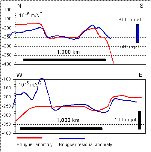
Fig. 12. Bouguer gravity profiles taken from the fields in Fig. 10 and Fig. 11.
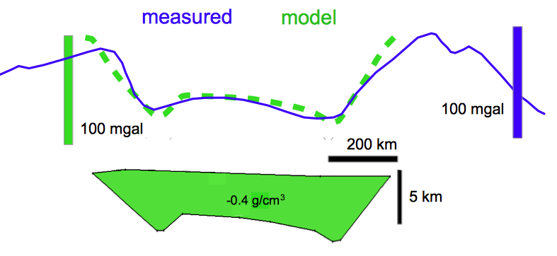
Fig. 13. Simple density model for the Taklamakan dessert basin.
The N – S gravity profile has been selected for a very simple 2.5D model calculation the result of which is shown in Fig, 13. For lack of more specific density and structural data the modeling has produced a two-layer density distribution that assumes a mass deficit responsible for the central negative gravity anomaly. Because of this simple assumption the shape of the negative mass follows more or less the shape of the gravity curve. This reveals a central depression with reduced density and a depth of roughly 5 – 8 km.
4 Discussion
As the title of the article emphasizes, the interpretation of the Taklamakan basin is marked with a question mark, which does not need to be stressed enough here. The starting point for the present investigations is the morphology of the basin, which with the topographic profiles taken from Google Earth describes a strikingly elliptical structure, consisting mainly of the desert plain and a steeply rising mountain range all around. The morphological crossing of the basin’s rim, which is also striking, is emphasized by elevation profiles, which can be followed almost congruently despite distances of up to 200 km. It is not easy to cite a geological process for the formation of this huge basin that produces such a pronounced geometry. Apparently the elliptical structuring continues into the interior, which is partially traced by the drainage system (Fig. 2) and obviously by valley vegetation seen in Google Earth (Fig. 8).
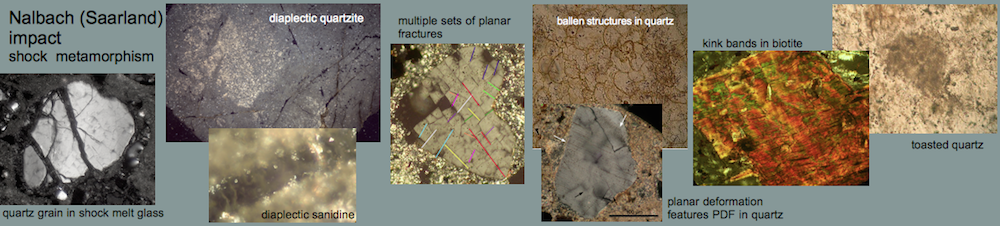
At this point a possible impact comes into discussion. If we stick to pure morphology, the ellipticity is not a particular problem if we assume that a largely round structure was formed directly at the impact. In the Precambrian Sudbury impact, we see today an elongated, roughly elliptical structure (Fig. 13), which has been compressed by subsequent tectonic processes of mountain building.
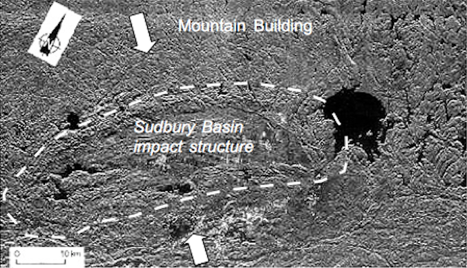
Fig. 13. Tectonically deformed Sudbury impact structure (Canada). Original size of the structure 200 – 250 km. Source: NASA.
As Fig. 14 shows, this could also be imagined for the Taklamakan Basin. In this case, what turned the circle into an ellipse? For this, we have to look at Fig. 15 and try to understand plate tectonics.
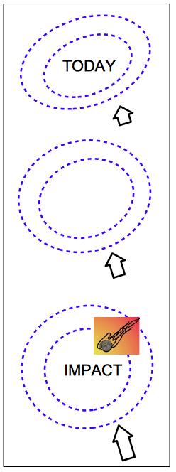
Fig. 14. From circular impact to compressed elliptical structure.
The sectional map in Fig. 15 shows the framing of the Indian Plate with the collision zone to the Eurasian Plate in the north and the pressing of the Himalaya Mountains. In the same figure the Taklamakan basin is sketched. The direction of movement of the Indian plate is shown by the arrow, and it does not necessarily require enormous imagination to see here the possible thrust for compressing an originally circular impact structure into a roughly transverse ellipse.
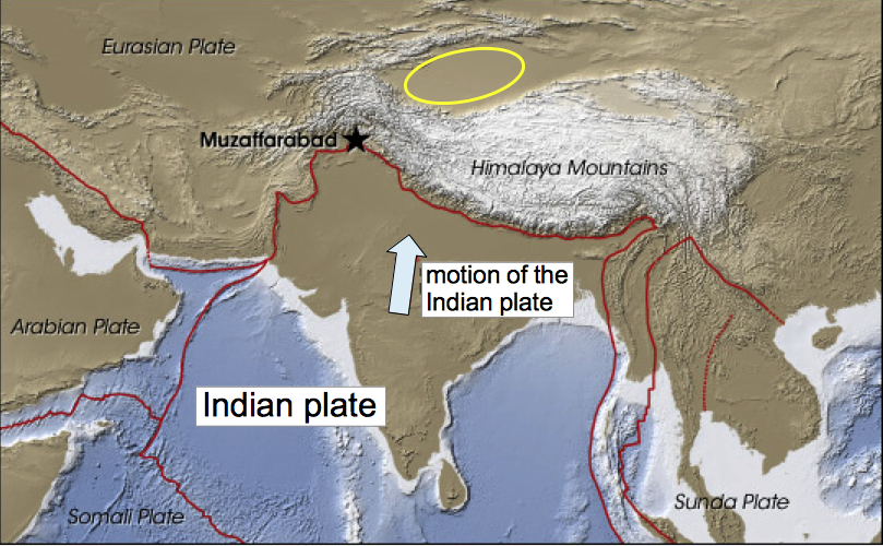
Fig. 15. Plate tectonics: The Indian plate motion against the Eurasian plate. Yellow ellipse: the Taklamakan basin. Modified from NASA.
We come to gravimetry. Gravity measurements have been used for a long time and for many impact structures [e.g., 2] to explore the internal and external structure, to estimate excavated and ejected masses and to calculate impact energies.
If we want to relate the gravity map of Fig. 11 to the basin structure, we first have to explain why both appear shifted against each other (Fig. 16). For readers who are not so familiar with gravimetry, Fig. 17 gives the characteristic example for the gravimetry of the well known Ries impact structure (Germany), which is much smaller, but makes the connections particularly clear. For the Ries, a wide-area gravity survey was first carried out (Fig. 17, left) which shows the negative gravity anomaly already known from very early pendulum measurements. As can easily be seen, the center of the negative anomaly is strongly eccentrically shifted towards the rim of the impact basin. A construction of a regional field that determines the large-scale mass distributions deep in the Earth’s crust and overlays the local Ries anomaly has been deducted in Fig. 17, right, whereupon the impact-related Ries anomaly has moved almost to the center of the crater structure (where it actually belongs).
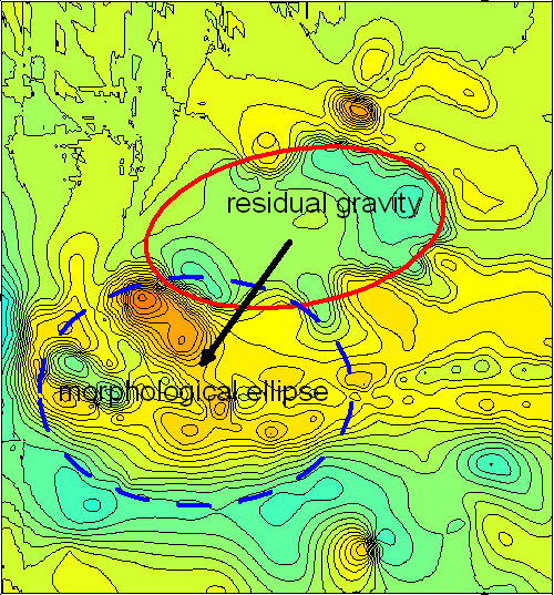
Fig. 16. The location of the morphological basin (Fig. 7) and the possibly shifted residual gravity anomaly.
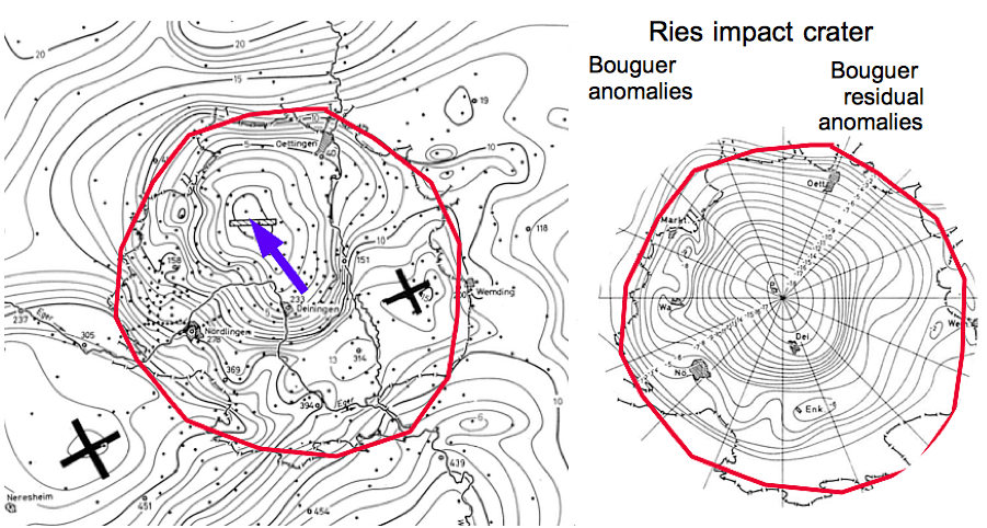
Fig. 17. Gravity anomalies of the Ries impact structure: originally measured field (left) [3] and residual field after removal of a regional field [4].
Returning to the Taklamakan Basin and the shifted gravity anomaly of the residual field (Fig. 16), we concede that here a regional field has already been subtracted from the original Bouguer gravity (Fig. 11). However, as already mentioned there, this was only a makeshift solution, since the further distribution of gravity in a much larger frame is not known due to lack of data. If we consider that on a large scale and at great depth in the plate tectonic collision zone with the submerged Indian plate and the huge Himalayan anomaly, as well as completely missing data in the north of the basin, a true regional field is ultimately unknown, and the discernible shift must appear quite understandable.
Let us therefore concentrate on the gravity anomaly itself and the gravity profiles in Fig. 12. A very first very rough modeling shows a mass deficit that reaches down several kilometers and that adapts with its base to the gravity curve. If instead of the selected density difference of -0.4 g/cm3 a half as large difference is chosen (-0.2 g/cm3), the mass deficit extends over 10 km down. Of course, many other mass distributions can also be adapted to the measurement curve, but in view of a very first idea of a mass distribution, this is not given here and also makes little sense.
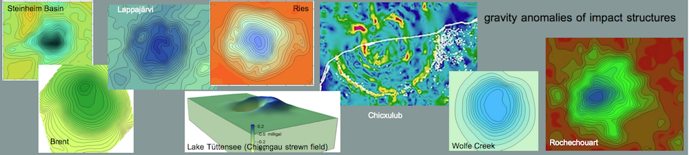
More interesting is the general course of gravity along the intersecting profiles in the center (Fig. 18) with a relative maximum in the middle bordered by marginal minima. This shape strongly reminds of gravity curves of other large impact structures, which are added in Fig. 18 for comparison.
In general, such a central gravity maximum is explained by the fact that in large complex impact structures, the transient crater collapses during the modification phase of impact cratering, in which the hollow form is largely filled up again and, together with elastic rebound, inner rings and/or central uplifts are formed. As the density in the earth’s crust generally increases downwards, a mass uplift from the depths can result in positive gravity anomalies in the interior.
Accordingly, also a ring anomaly can form in large impact structures instead of a central one, as the profiles for the Popigai and Lairg impact structures in Russia and northern Scotland show (Fig. 18).
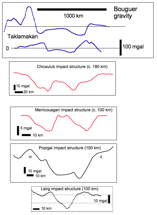
Fig. 18. Bouguer gravity profiles for the Taklamakan basin and, for comparison, the Chicxulub and the Manicouagan impact structures (red). Despite the clearly different sizes a certain similarity cannot be ignored. As mentioned in the text, instead of the central positive anomaly, relatively positive ring anomalies can also occur, which the two lower profiles convey. 50 km diameter has also been discussed for the Lairg impact, but only the inner ring has been considered. The comparison profiles were taken from [5] in a slightly modified form.
While the gravity patterns used here for comparison refer to impact structures that are an order of magnitude smaller than the Taklamakan Basin, its more comparable Wilkes Land anomaly has been discussed for some time as an expression of a massive impact structure under the Antarctic ice [6]. It has only recently been highlighted by a new gravity survey from satellites, in which a 500 km round gravity peak surrounded by a ring of relatively negative anomalies within a topographic bedrock depression has been sketched more precisely (Fig. 19).
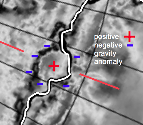
Fig. 19. The Wilkes Land gravity anomaly simplified and modified from [7]. The red line is a section of the profile line in Fig. 20.
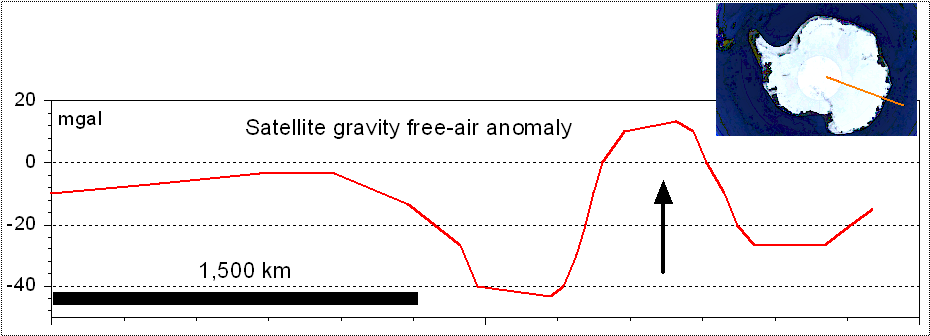
Fig. 20. Wilkes Land (Antarctica): suspected mega impact below the ice sheet. Gravity free-air anomaly from satellite data. The positive anomaly in the center (arrow) has been ascribed to Earth mantle isostatic uplift [6] after the impact. Profile digitized from a previous gravity contour map [8, Fig. 1].
The Wilkes Land structure, which has so far been classified as a possible or probable impact structure by some impact databases, and which approaches the scale of the Taklamakan Basin, shows that mega-impact structures can still be identified as worthy of discussion today, even if they are not directly accessible and no samples are available yet.
The gravity anomalies of both mega-structures look quite similar with roughly comparable amplitudes and a central relatively positive anomaly surrounded by relatively negative edge anomalies. If at Wilkes Land Crater the central mass accumulation (“Mascon”) with isostatic compensation by ascent of denser mantle material is plausibly explained [6], in case of an impact also at Taklamakan similar processes have to be considered, although the conditions in the collision area between the Indian and Eurasian plate are likely to be much more complex.
Readers who are not so familiar with impact processes and who are concerned about the size of the impactor that may have created the giant structure can assume that it was several tens of kilometers in diameter. The question of whether there is anything left of this body deep down in the crust and mantle of the Earth, or whether it has also undergone compression by the Indian plate, must be answered to the effect that, according to the findings of impact research, when the projectile hits the Earth at cosmic speed, it practically vaporizes completely.
We want to leave it here for the time being, but not before the question of the age of a possible impact has been addressed.
According to the suggestion that the elliptical structure emerged from an originally circular impact structure by pressure from the Indian Plate, the postulated event must have happened before the Indian Plate separated from Gondwana (roughly 100 million years ago) or during its movement northwards. According to [9], the collision with the Eurasian plate is said to have started about 55 million years ago. Thus, a possible impact event remains rather undetermined in time; it may also have occurred in much earlier geological times. If the impact occurred at all, this could be indicated by the fact that the excavation must have produced enormous amounts of ejecta, which would probably have to exist in part in a more recent impact today, if they were identified as such. A speculative, associated possible mass extinction is to be completely left out.
5 Conclusions
The story with the Chinese Taklamakan Desert structure begins with an amateur’s interest in geological phenomena, but with a scientific background. There are many such amateurs and much more than is perhaps assumed, and the author makes in many cases immensely positive experiences with them, especially when it turns out that the finds and findings bring further scientific knowledge. In this connection it is to be stated that in recent time a set of newly discovered impacts was furnished not by geologists or impact researchers but only by amateurs, who collected and documented, partly for years, large quantities of rocks, provided maps, manufactured preparations and looked into the microscope, which led also to publications, but which is largely ignored by established impact research.
In the Taklamakan case, for the time being, it must remain open what is behind it, but here too, the impetus for a potentially significant scientific result could once again have come from a lay researcher and amateur.
Acknowledgement – Akshay Saxena gave the first indication of the remarkable structure in China and gave some useful suggestions for improvement of the manuscript.
References
[1] Gfex –https://www.gifex.com/detail-en/2011-08-03-14241/Bouguer_gravity_anomaly_in_China.html
[2] Sweeny, J.F. (1978): Gravity study of great impact. Journal of Geophysical Research, 83, 2809-2815.
[3] Jung, K. and Schaaf, H. (1967): Gravimetermessungen im Nördlinger Ries und seiner Umgebung, Abschätzung der gesamten Defizitmasse. – Z. Geophysik, 33, 319-345.
[4] Kahle, H.-G. (1969): Abschätzung der Störungsmasse im Nördlinger Ries. – Z. Geophysik, 35, 317-345.
[5] Simms, M.J. and Ernstson, K. (2019): A reassessment of the proposed ‘Lairg Impact Structure’ and its potential implications for the deep structure of northern Scotland. – J. Geological Society, 176, 443-446.
[6] von Frese, R.R.B., Potts, L.V., Wells, S.B. and Leftwich, T.E., Rae Kim, .,Woo Kim, J., Golynsky, A.V., Hernandez, O., Gaya-Pique ́, L.R. (2009): GRACE gravity evidence for an impact basin in Wilkes Land, Antarctica. – Geochemistry Geophysics Geosystems, 10 (2), 14 p., doi:10.1029/2008GC002149 ISSN: 1525-2027.
[7] Klokočník1, J., Kostelecký, J., and Aleš Bezděk1, A. (2018): On the detection of the Wilkes Land impact crater. – Earth, Planets and Space, 70:135 https://doi.org/10.1186/s40623-018-0904-7.
[8] Weihaupt, J.G., Rice, A. and Van der Hoeven, F.G. (2010): Gravity anomalies of the Antarctic lithosphere. – Lithosphere, 2(6), 454-461.
[9] Scotese, C.R. (2001): The Collision of India and Asia (90 mya – Present). Deformation of Asia and the formation of the Himalayas and Tibetan Plateau. – http://www.scotese.com/indianim.htm